Home > Maps > Canadian Topographic Maps > Canadian Topographic Block 025

Canadian Topographic Maps - Topo Block 025


1:250 000 and 1:50 000 scale NTS Maps

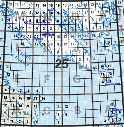
Click on an area of the map below to zoom in on each topo map index.

Back to the Quebec Topographical Maps Index.

Back to the Newfoundland and Labrador Topographical Maps Index.

Back to the Nunavut Topographical Maps Index.

Each lettered square on the topo map index above represents the following 1:250 000 scale topographic maps: 25A - Grenfell Sound, 25B - Part Of 025C Akpatok Island, 25C - Akpatok Island, 25D - Rivière Arnaud (Payne), 25E - Kangiqsujuaq, 25F - Part Of 025E Kangiqsujuaq.

Click on the topo map index above to see more detailed maps and information about Quebec topographical maps.

Sort By:
Page of 7
025A - GRENFELL SOUND - Topographic Map 025A01E - HOME ISLAND - Topographic Map 025A01W - HOME ISLAND - Topographic Map
The Canadian 1:250,000 scale paper topographic map series also known as topo or topographical maps is very useful for providing an overview of an area.  These paper or laminated maps include contour lines, water bodies, roads, population centres, treed areas, etc. Printed topo maps are great for recreational activities such as hiking, camping, biking or fishing.  Topographic maps have latitude and longitute and UTM coordinates. Topo maps can be used with a compass or a GPS unit.  Canadian topographical paper maps can be laminated - makes map waterproof - for an additional charge. As the most detailed country-wide map series, the 1:50,000 paper topographic series also known as topo or topographical is ideal for any purpose that requires good detail of an area.  These topographical paper maps include contour lines, water bodies, roads, trails, population centres, treed areas, etc. Printed Topo maps are great for recreational activities such as hiking, camping, biking or fishing.  Topographic maps have latitude and longitute and UTM coordinates. Topo paper maps can be used with a compass or a GPS unit. Printed Canadian topographical maps can be laminated - makes map waterproof - for an additional charge. As the most detailed country-wide map series, the 1:50,000 paper topographic series also known as topo or topographical is ideal for any purpose that requires good detail of an area.  These topographical paper maps include contour lines, water bodies, roads, trails, population centres, treed areas, etc. Printed Topo maps are great for recreational activities such as hiking, camping, biking or fishing.  Topographic maps have latitude and longitute and UTM coordinates. Topo paper maps can be used with a compass or a GPS unit. Printed Canadian topographical maps can be laminated - makes map waterproof - for an additional charge.
025A02E - IKKUDLIAYUK FIORD - Topographic Map 025A02W - IKKUDLIAYUK FIORD - Topographic Map 025A03E - SINGER INLET - Topographic Map
As the most detailed country-wide map series, the 1:50,000 paper topographic series also known as topo or topographical is ideal for any purpose that requires good detail of an area.  These topographical paper maps include contour lines, water bodies, roads, trails, population centres, treed areas, etc. Printed Topo maps are great for recreational activities such as hiking, camping, biking or fishing.  Topographic maps have latitude and longitute and UTM coordinates. Topo paper maps can be used with a compass or a GPS unit. Printed Canadian topographical maps can be laminated - makes map waterproof - for an additional charge. As the most detailed country-wide map series, the 1:50,000 paper topographic series also known as topo or topographical is ideal for any purpose that requires good detail of an area.  These topographical paper maps include contour lines, water bodies, roads, trails, population centres, treed areas, etc. Printed Topo maps are great for recreational activities such as hiking, camping, biking or fishing.  Topographic maps have latitude and longitute and UTM coordinates. Topo paper maps can be used with a compass or a GPS unit. Printed Canadian topographical maps can be laminated - makes map waterproof - for an additional charge. As the most detailed country-wide map series, the 1:50,000 paper topographic series also known as topo or topographical is ideal for any purpose that requires good detail of an area.  These topographical paper maps include contour lines, water bodies, roads, trails, population centres, treed areas, etc. Printed Topo maps are great for recreational activities such as hiking, camping, biking or fishing.  Topographic maps have latitude and longitute and UTM coordinates. Topo paper maps can be used with a compass or a GPS unit. Printed Canadian topographical maps can be laminated - makes map waterproof - for an additional charge.
025A07E - KILLINIQ ISLAND - Topographic Map 025A07W - KILLINIQ ISLAND - Topographic Map 025A08W - CAPE CHIDLEY - Topographic Map
As the most detailed country-wide map series, the 1:50,000 paper topographic series also known as topo or topographical is ideal for any purpose that requires good detail of an area.  These topographical paper maps include contour lines, water bodies, roads, trails, population centres, treed areas, etc. Printed Topo maps are great for recreational activities such as hiking, camping, biking or fishing.  Topographic maps have latitude and longitute and UTM coordinates. Topo paper maps can be used with a compass or a GPS unit. Printed Canadian topographical maps can be laminated - makes map waterproof - for an additional charge. As the most detailed country-wide map series, the 1:50,000 paper topographic series also known as topo or topographical is ideal for any purpose that requires good detail of an area.  These topographical paper maps include contour lines, water bodies, roads, trails, population centres, treed areas, etc. Printed Topo maps are great for recreational activities such as hiking, camping, biking or fishing.  Topographic maps have latitude and longitute and UTM coordinates. Topo paper maps can be used with a compass or a GPS unit. Printed Canadian topographical maps can be laminated - makes map waterproof - for an additional charge. As the most detailed country-wide map series, the 1:50,000 paper topographic series also known as topo or topographical is ideal for any purpose that requires good detail of an area.  These topographical paper maps include contour lines, water bodies, roads, trails, population centres, treed areas, etc. Printed Topo maps are great for recreational activities such as hiking, camping, biking or fishing.  Topographic maps have latitude and longitute and UTM coordinates. Topo paper maps can be used with a compass or a GPS unit. Printed Canadian topographical maps can be laminated - makes map waterproof - for an additional charge.
025A10E - BUTTON ISLANDS - Topographic Map 025A10W - BUTTON ISLANDS - Topographic Map 025B05 - HANHAM HILL - Topographic Map
As the most detailed country-wide map series, the 1:50,000 paper topographic series also known as topo or topographical is ideal for any purpose that requires good detail of an area.  These topographical paper maps include contour lines, water bodies, roads, trails, population centres, treed areas, etc. Printed Topo maps are great for recreational activities such as hiking, camping, biking or fishing.  Topographic maps have latitude and longitute and UTM coordinates. Topo paper maps can be used with a compass or a GPS unit. Printed Canadian topographical maps can be laminated - makes map waterproof - for an additional charge. As the most detailed country-wide map series, the 1:50,000 paper topographic series also known as topo or topographical is ideal for any purpose that requires good detail of an area.  These topographical paper maps include contour lines, water bodies, roads, trails, population centres, treed areas, etc. Printed Topo maps are great for recreational activities such as hiking, camping, biking or fishing.  Topographic maps have latitude and longitute and UTM coordinates. Topo paper maps can be used with a compass or a GPS unit. Printed Canadian topographical maps can be laminated - makes map waterproof - for an additional charge. As the most detailed country-wide map series, the 1:50,000 paper topographic series also known as topo or topographical is ideal for any purpose that requires good detail of an area.  These topographical paper maps include contour lines, water bodies, roads, trails, population centres, treed areas, etc. Printed Topo maps are great for recreational activities such as hiking, camping, biking or fishing.  Topographic maps have latitude and longitute and UTM coordinates. Topo paper maps can be used with a compass or a GPS unit. Printed Canadian topographical maps can be laminated - makes map waterproof - for an additional charge.
025B12 - HELL POINT - Topographic Map 025C - AKPATOK ISLAND - Topographic Map 025C01 - CLUTTERBUCK HEAD - Topographic Map
As the most detailed country-wide map series, the 1:50,000 paper topographic series also known as topo or topographical is ideal for any purpose that requires good detail of an area.  These topographical paper maps include contour lines, water bodies, roads, trails, population centres, treed areas, etc. Printed Topo maps are great for recreational activities such as hiking, camping, biking or fishing.  Topographic maps have latitude and longitute and UTM coordinates. Topo paper maps can be used with a compass or a GPS unit. Printed Canadian topographical maps can be laminated - makes map waterproof - for an additional charge. The Canadian 1:250,000 scale paper topographic map series also known as topo or topographical maps is very useful for providing an overview of an area.  These paper or laminated maps include contour lines, water bodies, roads, population centres, treed areas, etc. Printed topo maps are great for recreational activities such as hiking, camping, biking or fishing.  Topographic maps have latitude and longitute and UTM coordinates. Topo maps can be used with a compass or a GPS unit.  Canadian topographical paper maps can be laminated - makes map waterproof - for an additional charge. As the most detailed country-wide map series, the 1:50,000 paper topographic series also known as topo or topographical is ideal for any purpose that requires good detail of an area.  These topographical paper maps include contour lines, water bodies, roads, trails, population centres, treed areas, etc. Printed Topo maps are great for recreational activities such as hiking, camping, biking or fishing.  Topographic maps have latitude and longitute and UTM coordinates. Topo paper maps can be used with a compass or a GPS unit. Printed Canadian topographical maps can be laminated - makes map waterproof - for an additional charge.
025C04E - KYAK BAY - Topographic Map 025C04W - KYAK BAY - Topographic Map 025C05E - PLOVER ISLANDS - Topographic Map
As the most detailed country-wide map series, the 1:50,000 paper topographic series also known as topo or topographical is ideal for any purpose that requires good detail of an area.  These topographical paper maps include contour lines, water bodies, roads, trails, population centres, treed areas, etc. Printed Topo maps are great for recreational activities such as hiking, camping, biking or fishing.  Topographic maps have latitude and longitute and UTM coordinates. Topo paper maps can be used with a compass or a GPS unit. Printed Canadian topographical maps can be laminated - makes map waterproof - for an additional charge. As the most detailed country-wide map series, the 1:50,000 paper topographic series also known as topo or topographical is ideal for any purpose that requires good detail of an area.  These topographical paper maps include contour lines, water bodies, roads, trails, population centres, treed areas, etc. Printed Topo maps are great for recreational activities such as hiking, camping, biking or fishing.  Topographic maps have latitude and longitute and UTM coordinates. Topo paper maps can be used with a compass or a GPS unit. Printed Canadian topographical maps can be laminated - makes map waterproof - for an additional charge. As the most detailed country-wide map series, the 1:50,000 paper topographic series also known as topo or topographical is ideal for any purpose that requires good detail of an area.  These topographical paper maps include contour lines, water bodies, roads, trails, population centres, treed areas, etc. Printed Topo maps are great for recreational activities such as hiking, camping, biking or fishing.  Topographic maps have latitude and longitute and UTM coordinates. Topo paper maps can be used with a compass or a GPS unit. Printed Canadian topographical maps can be laminated - makes map waterproof - for an additional charge.
025C05W - PLOVER ISLANDS - Topographic Map 025C06 - NO TITLE - Topographic Map 025C08 - BRAY HILL - Topographic Map
As the most detailed country-wide map series, the 1:50,000 paper topographic series also known as topo or topographical is ideal for any purpose that requires good detail of an area.  These topographical paper maps include contour lines, water bodies, roads, trails, population centres, treed areas, etc. Printed Topo maps are great for recreational activities such as hiking, camping, biking or fishing.  Topographic maps have latitude and longitute and UTM coordinates. Topo paper maps can be used with a compass or a GPS unit. Printed Canadian topographical maps can be laminated - makes map waterproof - for an additional charge. As the most detailed country-wide map series, the 1:50,000 paper topographic series also known as topo or topographical is ideal for any purpose that requires good detail of an area.  These topographical paper maps include contour lines, water bodies, roads, trails, population centres, treed areas, etc. Printed Topo maps are great for recreational activities such as hiking, camping, biking or fishing.  Topographic maps have latitude and longitute and UTM coordinates. Topo paper maps can be used with a compass or a GPS unit. Printed Canadian topographical maps can be laminated - makes map waterproof - for an additional charge. As the most detailed country-wide map series, the 1:50,000 paper topographic series also known as topo or topographical is ideal for any purpose that requires good detail of an area.  These topographical paper maps include contour lines, water bodies, roads, trails, population centres, treed areas, etc. Printed Topo maps are great for recreational activities such as hiking, camping, biking or fishing.  Topographic maps have latitude and longitute and UTM coordinates. Topo paper maps can be used with a compass or a GPS unit. Printed Canadian topographical maps can be laminated - makes map waterproof - for an additional charge.
025C09 - SINGER POINT - Topographic Map 025C12E - BAIE DE ROZIERE - Topographic Map 025C12W - BAIE DE ROZIERE - Topographic Map
As the most detailed country-wide map series, the 1:50,000 paper topographic series also known as topo or topographical is ideal for any purpose that requires good detail of an area.  These topographical paper maps include contour lines, water bodies, roads, trails, population centres, treed areas, etc. Printed Topo maps are great for recreational activities such as hiking, camping, biking or fishing.  Topographic maps have latitude and longitute and UTM coordinates. Topo paper maps can be used with a compass or a GPS unit. Printed Canadian topographical maps can be laminated - makes map waterproof - for an additional charge. As the most detailed country-wide map series, the 1:50,000 paper topographic series also known as topo or topographical is ideal for any purpose that requires good detail of an area.  These topographical paper maps include contour lines, water bodies, roads, trails, population centres, treed areas, etc. Printed Topo maps are great for recreational activities such as hiking, camping, biking or fishing.  Topographic maps have latitude and longitute and UTM coordinates. Topo paper maps can be used with a compass or a GPS unit. Printed Canadian topographical maps can be laminated - makes map waterproof - for an additional charge. As the most detailed country-wide map series, the 1:50,000 paper topographic series also known as topo or topographical is ideal for any purpose that requires good detail of an area.  These topographical paper maps include contour lines, water bodies, roads, trails, population centres, treed areas, etc. Printed Topo maps are great for recreational activities such as hiking, camping, biking or fishing.  Topographic maps have latitude and longitute and UTM coordinates. Topo paper maps can be used with a compass or a GPS unit. Printed Canadian topographical maps can be laminated - makes map waterproof - for an additional charge.
025C13E - DIANA BAY - Topographic Map 025C13W - DIANA BAY - Topographic Map 025C14W - EIDER ISLANDS - Topographic Map
As the most detailed country-wide map series, the 1:50,000 paper topographic series also known as topo or topographical is ideal for any purpose that requires good detail of an area.  These topographical paper maps include contour lines, water bodies, roads, trails, population centres, treed areas, etc. Printed Topo maps are great for recreational activities such as hiking, camping, biking or fishing.  Topographic maps have latitude and longitute and UTM coordinates. Topo paper maps can be used with a compass or a GPS unit. Printed Canadian topographical maps can be laminated - makes map waterproof - for an additional charge. As the most detailed country-wide map series, the 1:50,000 paper topographic series also known as topo or topographical is ideal for any purpose that requires good detail of an area.  These topographical paper maps include contour lines, water bodies, roads, trails, population centres, treed areas, etc. Printed Topo maps are great for recreational activities such as hiking, camping, biking or fishing.  Topographic maps have latitude and longitute and UTM coordinates. Topo paper maps can be used with a compass or a GPS unit. Printed Canadian topographical maps can be laminated - makes map waterproof - for an additional charge. As the most detailed country-wide map series, the 1:50,000 paper topographic series also known as topo or topographical is ideal for any purpose that requires good detail of an area.  These topographical paper maps include contour lines, water bodies, roads, trails, population centres, treed areas, etc. Printed Topo maps are great for recreational activities such as hiking, camping, biking or fishing.  Topographic maps have latitude and longitute and UTM coordinates. Topo paper maps can be used with a compass or a GPS unit. Printed Canadian topographical maps can be laminated - makes map waterproof - for an additional charge.
025D - RIVIERE ARNAUD (PAYNE) - Topographic Map 025D01 - KANGIRSUK - Topographic Map 025D02E - LAC TREMPE - Topographic Map
The Canadian 1:250,000 scale paper topographic map series also known as topo or topographical maps is very useful for providing an overview of an area.  These paper or laminated maps include contour lines, water bodies, roads, population centres, treed areas, etc. Printed topo maps are great for recreational activities such as hiking, camping, biking or fishing.  Topographic maps have latitude and longitute and UTM coordinates. Topo maps can be used with a compass or a GPS unit.  Canadian topographical paper maps can be laminated - makes map waterproof - for an additional charge. As the most detailed country-wide map series, the 1:50,000 paper topographic series also known as topo or topographical is ideal for any purpose that requires good detail of an area.  These topographical paper maps include contour lines, water bodies, roads, trails, population centres, treed areas, etc. Printed Topo maps are great for recreational activities such as hiking, camping, biking or fishing.  Topographic maps have latitude and longitute and UTM coordinates. Topo paper maps can be used with a compass or a GPS unit. Printed Canadian topographical maps can be laminated - makes map waterproof - for an additional charge. As the most detailed country-wide map series, the 1:50,000 paper topographic series also known as topo or topographical is ideal for any purpose that requires good detail of an area.  These topographical paper maps include contour lines, water bodies, roads, trails, population centres, treed areas, etc. Printed Topo maps are great for recreational activities such as hiking, camping, biking or fishing.  Topographic maps have latitude and longitute and UTM coordinates. Topo paper maps can be used with a compass or a GPS unit. Printed Canadian topographical maps can be laminated - makes map waterproof - for an additional charge.