Home > Maps > Canadian Topographic Maps > Canadian Topographic Block 057

Canadian Topographic Maps - Nunavut


1:250 000 and 1:50 000 scale NTS Maps

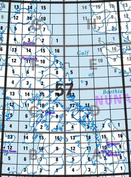
Click on the area below to retrieve topo maps from our database.

Back to the Nunavut Topo Maps Index.

Each lettered square on the topo map index above represents the following 1:250 000 scale topo maps: 57A - Pelly Bay, 57B - Rae Strait, 57C - Spence Bay, 57D - Harrison Islands, 57E - Easter Cape, 57F - Thom Bay, 57G - Brentford Bay, 57H - Bourassa Bay.

Sort By:
Page of 4
057A - PELLY BAY - Topographic Map 057A01 - MOUNT MACTAVISH - Topographic Map 057A02 - CAMERON LAKE - Topographic Map
The Canadian 1:250,000 scale paper topographic map series also known as topo or topographical maps is very useful for providing an overview of an area.  These paper or laminated maps include contour lines, water bodies, roads, population centres, treed areas, etc. Printed topo maps are great for recreational activities such as hiking, camping, biking or fishing.  Topographic maps have latitude and longitute and UTM coordinates. Topo maps can be used with a compass or a GPS unit.  Canadian topographical paper maps can be laminated - makes map waterproof - for an additional charge. As the most detailed country-wide map series, the 1:50,000 paper topographic series also known as topo or topographical is ideal for any purpose that requires good detail of an area.  These topographical paper maps include contour lines, water bodies, roads, trails, population centres, treed areas, etc. Printed Topo maps are great for recreational activities such as hiking, camping, biking or fishing.  Topographic maps have latitude and longitute and UTM coordinates. Topo paper maps can be used with a compass or a GPS unit. Printed Canadian topographical maps can be laminated - makes map waterproof - for an additional charge. As the most detailed country-wide map series, the 1:50,000 paper topographic series also known as topo or topographical is ideal for any purpose that requires good detail of an area.  These topographical paper maps include contour lines, water bodies, roads, trails, population centres, treed areas, etc. Printed Topo maps are great for recreational activities such as hiking, camping, biking or fishing.  Topographic maps have latitude and longitute and UTM coordinates. Topo paper maps can be used with a compass or a GPS unit. Printed Canadian topographical maps can be laminated - makes map waterproof - for an additional charge.
057A03 - TOURANGEAU CREEK - Topographic Map 057A04 - NO TITLE - Topographic Map 057A05 - NO TITLE - Topographic Map
As the most detailed country-wide map series, the 1:50,000 paper topographic series also known as topo or topographical is ideal for any purpose that requires good detail of an area.  These topographical paper maps include contour lines, water bodies, roads, trails, population centres, treed areas, etc. Printed Topo maps are great for recreational activities such as hiking, camping, biking or fishing.  Topographic maps have latitude and longitute and UTM coordinates. Topo paper maps can be used with a compass or a GPS unit. Printed Canadian topographical maps can be laminated - makes map waterproof - for an additional charge. As the most detailed country-wide map series, the 1:50,000 paper topographic series also known as topo or topographical is ideal for any purpose that requires good detail of an area.  These topographical paper maps include contour lines, water bodies, roads, trails, population centres, treed areas, etc. Printed Topo maps are great for recreational activities such as hiking, camping, biking or fishing.  Topographic maps have latitude and longitute and UTM coordinates. Topo paper maps can be used with a compass or a GPS unit. Printed Canadian topographical maps can be laminated - makes map waterproof - for an additional charge. As the most detailed country-wide map series, the 1:50,000 paper topographic series also known as topo or topographical is ideal for any purpose that requires good detail of an area.  These topographical paper maps include contour lines, water bodies, roads, trails, population centres, treed areas, etc. Printed Topo maps are great for recreational activities such as hiking, camping, biking or fishing.  Topographic maps have latitude and longitute and UTM coordinates. Topo paper maps can be used with a compass or a GPS unit. Printed Canadian topographical maps can be laminated - makes map waterproof - for an additional charge.
057A06 - DE STAEL POINT - Topographic Map 057A07 - BARROW LAKE - Topographic Map 057A08 - KEITH BAY - Topographic Map
As the most detailed country-wide map series, the 1:50,000 paper topographic series also known as topo or topographical is ideal for any purpose that requires good detail of an area.  These topographical paper maps include contour lines, water bodies, roads, trails, population centres, treed areas, etc. Printed Topo maps are great for recreational activities such as hiking, camping, biking or fishing.  Topographic maps have latitude and longitute and UTM coordinates. Topo paper maps can be used with a compass or a GPS unit. Printed Canadian topographical maps can be laminated - makes map waterproof - for an additional charge. As the most detailed country-wide map series, the 1:50,000 paper topographic series also known as topo or topographical is ideal for any purpose that requires good detail of an area.  These topographical paper maps include contour lines, water bodies, roads, trails, population centres, treed areas, etc. Printed Topo maps are great for recreational activities such as hiking, camping, biking or fishing.  Topographic maps have latitude and longitute and UTM coordinates. Topo paper maps can be used with a compass or a GPS unit. Printed Canadian topographical maps can be laminated - makes map waterproof - for an additional charge. As the most detailed country-wide map series, the 1:50,000 paper topographic series also known as topo or topographical is ideal for any purpose that requires good detail of an area.  These topographical paper maps include contour lines, water bodies, roads, trails, population centres, treed areas, etc. Printed Topo maps are great for recreational activities such as hiking, camping, biking or fishing.  Topographic maps have latitude and longitute and UTM coordinates. Topo paper maps can be used with a compass or a GPS unit. Printed Canadian topographical maps can be laminated - makes map waterproof - for an additional charge.
057A09 - NO TITLE - Topographic Map 057A10 - LOGIN BAY - Topographic Map 057A11 - BECHER RIVER - Topographic Map
As the most detailed country-wide map series, the 1:50,000 paper topographic series also known as topo or topographical is ideal for any purpose that requires good detail of an area.  These topographical paper maps include contour lines, water bodies, roads, trails, population centres, treed areas, etc. Printed Topo maps are great for recreational activities such as hiking, camping, biking or fishing.  Topographic maps have latitude and longitute and UTM coordinates. Topo paper maps can be used with a compass or a GPS unit. Printed Canadian topographical maps can be laminated - makes map waterproof - for an additional charge. As the most detailed country-wide map series, the 1:50,000 paper topographic series also known as topo or topographical is ideal for any purpose that requires good detail of an area.  These topographical paper maps include contour lines, water bodies, roads, trails, population centres, treed areas, etc. Printed Topo maps are great for recreational activities such as hiking, camping, biking or fishing.  Topographic maps have latitude and longitute and UTM coordinates. Topo paper maps can be used with a compass or a GPS unit. Printed Canadian topographical maps can be laminated - makes map waterproof - for an additional charge. As the most detailed country-wide map series, the 1:50,000 paper topographic series also known as topo or topographical is ideal for any purpose that requires good detail of an area.  These topographical paper maps include contour lines, water bodies, roads, trails, population centres, treed areas, etc. Printed Topo maps are great for recreational activities such as hiking, camping, biking or fishing.  Topographic maps have latitude and longitute and UTM coordinates. Topo paper maps can be used with a compass or a GPS unit. Printed Canadian topographical maps can be laminated - makes map waterproof - for an additional charge.
057A12 - EUPHEMIA HILL - Topographic Map 057A13 - BURWASH LAKE - Topographic Map 057A14 - NO TITLE - Topographic Map
As the most detailed country-wide map series, the 1:50,000 paper topographic series also known as topo or topographical is ideal for any purpose that requires good detail of an area.  These topographical paper maps include contour lines, water bodies, roads, trails, population centres, treed areas, etc. Printed Topo maps are great for recreational activities such as hiking, camping, biking or fishing.  Topographic maps have latitude and longitute and UTM coordinates. Topo paper maps can be used with a compass or a GPS unit. Printed Canadian topographical maps can be laminated - makes map waterproof - for an additional charge. As the most detailed country-wide map series, the 1:50,000 paper topographic series also known as topo or topographical is ideal for any purpose that requires good detail of an area.  These topographical paper maps include contour lines, water bodies, roads, trails, population centres, treed areas, etc. Printed Topo maps are great for recreational activities such as hiking, camping, biking or fishing.  Topographic maps have latitude and longitute and UTM coordinates. Topo paper maps can be used with a compass or a GPS unit. Printed Canadian topographical maps can be laminated - makes map waterproof - for an additional charge. As the most detailed country-wide map series, the 1:50,000 paper topographic series also known as topo or topographical is ideal for any purpose that requires good detail of an area.  These topographical paper maps include contour lines, water bodies, roads, trails, population centres, treed areas, etc. Printed Topo maps are great for recreational activities such as hiking, camping, biking or fishing.  Topographic maps have latitude and longitute and UTM coordinates. Topo paper maps can be used with a compass or a GPS unit. Printed Canadian topographical maps can be laminated - makes map waterproof - for an additional charge.
057A15 - NO TITLE - Topographic Map 057A16 - NO TITLE - Topographic Map 057B - RAE STRAIT - Topographic Map
As the most detailed country-wide map series, the 1:50,000 paper topographic series also known as topo or topographical is ideal for any purpose that requires good detail of an area.  These topographical paper maps include contour lines, water bodies, roads, trails, population centres, treed areas, etc. Printed Topo maps are great for recreational activities such as hiking, camping, biking or fishing.  Topographic maps have latitude and longitute and UTM coordinates. Topo paper maps can be used with a compass or a GPS unit. Printed Canadian topographical maps can be laminated - makes map waterproof - for an additional charge. As the most detailed country-wide map series, the 1:50,000 paper topographic series also known as topo or topographical is ideal for any purpose that requires good detail of an area.  These topographical paper maps include contour lines, water bodies, roads, trails, population centres, treed areas, etc. Printed Topo maps are great for recreational activities such as hiking, camping, biking or fishing.  Topographic maps have latitude and longitute and UTM coordinates. Topo paper maps can be used with a compass or a GPS unit. Printed Canadian topographical maps can be laminated - makes map waterproof - for an additional charge. The Canadian 1:250,000 scale paper topographic map series also known as topo or topographical maps is very useful for providing an overview of an area.  These paper or laminated maps include contour lines, water bodies, roads, population centres, treed areas, etc. Printed topo maps are great for recreational activities such as hiking, camping, biking or fishing.  Topographic maps have latitude and longitute and UTM coordinates. Topo maps can be used with a compass or a GPS unit.  Canadian topographical paper maps can be laminated - makes map waterproof - for an additional charge.
057B01 - MURCHISON LAKE - Topographic Map 057B02 - NO TITLE - Topographic Map 057B03 - NO TITLE - Topographic Map
As the most detailed country-wide map series, the 1:50,000 paper topographic series also known as topo or topographical is ideal for any purpose that requires good detail of an area.  These topographical paper maps include contour lines, water bodies, roads, trails, population centres, treed areas, etc. Printed Topo maps are great for recreational activities such as hiking, camping, biking or fishing.  Topographic maps have latitude and longitute and UTM coordinates. Topo paper maps can be used with a compass or a GPS unit. Printed Canadian topographical maps can be laminated - makes map waterproof - for an additional charge. As the most detailed country-wide map series, the 1:50,000 paper topographic series also known as topo or topographical is ideal for any purpose that requires good detail of an area.  These topographical paper maps include contour lines, water bodies, roads, trails, population centres, treed areas, etc. Printed Topo maps are great for recreational activities such as hiking, camping, biking or fishing.  Topographic maps have latitude and longitute and UTM coordinates. Topo paper maps can be used with a compass or a GPS unit. Printed Canadian topographical maps can be laminated - makes map waterproof - for an additional charge. As the most detailed country-wide map series, the 1:50,000 paper topographic series also known as topo or topographical is ideal for any purpose that requires good detail of an area.  These topographical paper maps include contour lines, water bodies, roads, trails, population centres, treed areas, etc. Printed Topo maps are great for recreational activities such as hiking, camping, biking or fishing.  Topographic maps have latitude and longitute and UTM coordinates. Topo paper maps can be used with a compass or a GPS unit. Printed Canadian topographical maps can be laminated - makes map waterproof - for an additional charge.
057B04 - CAPE BRITANNIA - Topographic Map 057B05W - HOVGAARD ISLANDS - Topographic Map 057B06 - CAPE SELKIRK - Topographic Map
As the most detailed country-wide map series, the 1:50,000 paper topographic series also known as topo or topographical is ideal for any purpose that requires good detail of an area.  These topographical paper maps include contour lines, water bodies, roads, trails, population centres, treed areas, etc. Printed Topo maps are great for recreational activities such as hiking, camping, biking or fishing.  Topographic maps have latitude and longitute and UTM coordinates. Topo paper maps can be used with a compass or a GPS unit. Printed Canadian topographical maps can be laminated - makes map waterproof - for an additional charge. As the most detailed country-wide map series, the 1:50,000 paper topographic series also known as topo or topographical is ideal for any purpose that requires good detail of an area.  These topographical paper maps include contour lines, water bodies, roads, trails, population centres, treed areas, etc. Printed Topo maps are great for recreational activities such as hiking, camping, biking or fishing.  Topographic maps have latitude and longitute and UTM coordinates. Topo paper maps can be used with a compass or a GPS unit. Printed Canadian topographical maps can be laminated - makes map waterproof - for an additional charge. As the most detailed country-wide map series, the 1:50,000 paper topographic series also known as topo or topographical is ideal for any purpose that requires good detail of an area.  These topographical paper maps include contour lines, water bodies, roads, trails, population centres, treed areas, etc. Printed Topo maps are great for recreational activities such as hiking, camping, biking or fishing.  Topographic maps have latitude and longitute and UTM coordinates. Topo paper maps can be used with a compass or a GPS unit. Printed Canadian topographical maps can be laminated - makes map waterproof - for an additional charge.
057B07 - CASTOR AND POLLUX RIVER - Topographic Map 057B08 - NO TITLE - Topographic Map 057B09 - FRANCES HILL - Topographic Map
As the most detailed country-wide map series, the 1:50,000 paper topographic series also known as topo or topographical is ideal for any purpose that requires good detail of an area.  These topographical paper maps include contour lines, water bodies, roads, trails, population centres, treed areas, etc. Printed Topo maps are great for recreational activities such as hiking, camping, biking or fishing.  Topographic maps have latitude and longitute and UTM coordinates. Topo paper maps can be used with a compass or a GPS unit. Printed Canadian topographical maps can be laminated - makes map waterproof - for an additional charge. As the most detailed country-wide map series, the 1:50,000 paper topographic series also known as topo or topographical is ideal for any purpose that requires good detail of an area.  These topographical paper maps include contour lines, water bodies, roads, trails, population centres, treed areas, etc. Printed Topo maps are great for recreational activities such as hiking, camping, biking or fishing.  Topographic maps have latitude and longitute and UTM coordinates. Topo paper maps can be used with a compass or a GPS unit. Printed Canadian topographical maps can be laminated - makes map waterproof - for an additional charge. As the most detailed country-wide map series, the 1:50,000 paper topographic series also known as topo or topographical is ideal for any purpose that requires good detail of an area.  These topographical paper maps include contour lines, water bodies, roads, trails, population centres, treed areas, etc. Printed Topo maps are great for recreational activities such as hiking, camping, biking or fishing.  Topographic maps have latitude and longitute and UTM coordinates. Topo paper maps can be used with a compass or a GPS unit. Printed Canadian topographical maps can be laminated - makes map waterproof - for an additional charge.
057B10 - ACLAND POINT - Topographic Map 057B11 - BRENDA ISLAND - Topographic Map 057B12E - GJOA HAVEN - Topographic Map
As the most detailed country-wide map series, the 1:50,000 paper topographic series also known as topo or topographical is ideal for any purpose that requires good detail of an area.  These topographical paper maps include contour lines, water bodies, roads, trails, population centres, treed areas, etc. Printed Topo maps are great for recreational activities such as hiking, camping, biking or fishing.  Topographic maps have latitude and longitute and UTM coordinates. Topo paper maps can be used with a compass or a GPS unit. Printed Canadian topographical maps can be laminated - makes map waterproof - for an additional charge. As the most detailed country-wide map series, the 1:50,000 paper topographic series also known as topo or topographical is ideal for any purpose that requires good detail of an area.  These topographical paper maps include contour lines, water bodies, roads, trails, population centres, treed areas, etc. Printed Topo maps are great for recreational activities such as hiking, camping, biking or fishing.  Topographic maps have latitude and longitute and UTM coordinates. Topo paper maps can be used with a compass or a GPS unit. Printed Canadian topographical maps can be laminated - makes map waterproof - for an additional charge. As the most detailed country-wide map series, the 1:50,000 paper topographic series also known as topo or topographical is ideal for any purpose that requires good detail of an area.  These topographical paper maps include contour lines, water bodies, roads, trails, population centres, treed areas, etc. Printed Topo maps are great for recreational activities such as hiking, camping, biking or fishing.  Topographic maps have latitude and longitute and UTM coordinates. Topo paper maps can be used with a compass or a GPS unit. Printed Canadian topographical maps can be laminated - makes map waterproof - for an additional charge.