Home > Maps > Canadian Topographic Maps > Canadian Topographic Block 082 > Canadian Topographic Block 082M

Canadian Topographic Maps - Block 082M


Use the following image to move to adjacent topo map indexes.

Sort By:
Page of 1
082M - SEYMOUR ARM - Topographic Map 082M01 - MOUNT REVELSTOKE - Topographic Map 082M02 - PERRY RIVER - Topographic Map
082M03 - ALBAS - Topographic Map 082M04 - ADAMS PLATEAU - Topographic Map 082M05 - NORTH BARRIERE LAKE - Topographic Map
082M06 - CAYENNE CREEK - Topographic Map 082M07 - RATCHFORD CREEK - Topographic Map 082M08 - DOWNIE CREEK - Topographic Map
082M09 - GOLDSTREAM RIVER - Topographic Map 082M10 - HOSKINS CREEK - Topographic Map 082M11 - ADAMS RIVER - Topographic Map
082M12 - VAVENBY - Topographic Map 082M13 - WEST RAFT RIVER - Topographic Map 082M14 - MESSITER - Topographic Map
082M15 - SCRIP CREEK - Topographic Map 082M16 - ARGONAUT MOUNTAIN - Topographic Map


Back to the Block 082 Topographic Map Index.

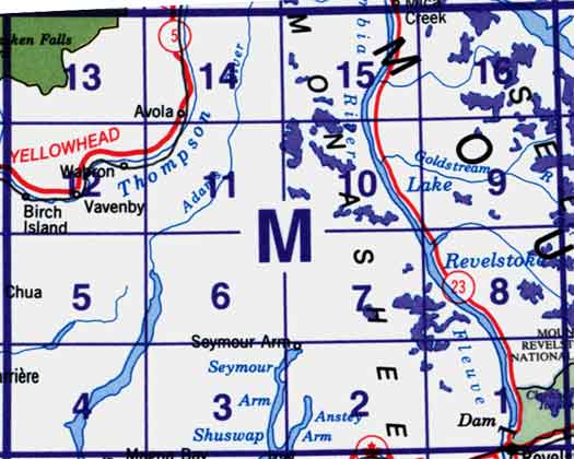
82M - Seymour Arm, 82M01 - Mount Revelstoke, 82M02 - Perry River, 82M03 - Albas, 82M04 - Adams Plateau, 82M05 - North Barrière Lake, 82M06 - Cayenne Creek, 82M07 - Ratchford Creek, 82M08 - Downie Creek, 82M09 - Goldstream River, 82M10 - Hoskins Creek, 82M11 - Adams River, 82M12 - Vavenby, 82M13 - West Raft River, 82M14 - Messiter, 82M15 - Scrip Creek, 82M16 - Argonaut Mountain. One or more of these maps cover the western portion of Mount Revelstoke National Park and the southern portion of Wells Grey Provincial Park