Home > Maps > Canadian Topographic Maps > Canadian Topographic Block 088

Canadian Topographic Maps - Northwest Territories


1:250 000 and 1:50 000 scale NTS Maps

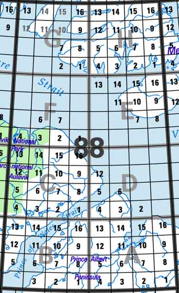
Click on the area below to retrieve topo maps from our database.

Back to the Northwest Territories Topographical Maps Index.

Each lettered square on the topo map index above represents the following 1:250 000 scale topographical maps: 88A - Richard Collinson Inlet, 88B - Deans Dundas Bay, 88C - White Sand Creek, 88D - Peel Point, 88E - Dundas Peninsula, 88F - Mercy Bay, 88G - Eglinton Island, 88H - Murray Inlet.

Sort By:
Page of 4
088A - RICHARD COLLINSON INLET - Topographic Map 088A01 - NO TITLE - Topographic Map 088A02 - NO TITLE - Topographic Map
The Canadian 1:250,000 scale paper topographic map series also known as topo or topographical maps is very useful for providing an overview of an area.  These paper or laminated maps include contour lines, water bodies, roads, population centres, treed areas, etc. Printed topo maps are great for recreational activities such as hiking, camping, biking or fishing.  Topographic maps have latitude and longitute and UTM coordinates. Topo maps can be used with a compass or a GPS unit.  Canadian topographical paper maps can be laminated - makes map waterproof - for an additional charge. As the most detailed country-wide map series, the 1:50,000 paper topographic series also known as topo or topographical is ideal for any purpose that requires good detail of an area.  These topographical paper maps include contour lines, water bodies, roads, trails, population centres, treed areas, etc. Printed Topo maps are great for recreational activities such as hiking, camping, biking or fishing.  Topographic maps have latitude and longitute and UTM coordinates. Topo paper maps can be used with a compass or a GPS unit. Printed Canadian topographical maps can be laminated - makes map waterproof - for an additional charge. As the most detailed country-wide map series, the 1:50,000 paper topographic series also known as topo or topographical is ideal for any purpose that requires good detail of an area.  These topographical paper maps include contour lines, water bodies, roads, trails, population centres, treed areas, etc. Printed Topo maps are great for recreational activities such as hiking, camping, biking or fishing.  Topographic maps have latitude and longitute and UTM coordinates. Topo paper maps can be used with a compass or a GPS unit. Printed Canadian topographical maps can be laminated - makes map waterproof - for an additional charge.
088A03 - NO TITLE - Topographic Map 088A04 - NO TITLE - Topographic Map 088A05 - NO TITLE - Topographic Map
As the most detailed country-wide map series, the 1:50,000 paper topographic series also known as topo or topographical is ideal for any purpose that requires good detail of an area.  These topographical paper maps include contour lines, water bodies, roads, trails, population centres, treed areas, etc. Printed Topo maps are great for recreational activities such as hiking, camping, biking or fishing.  Topographic maps have latitude and longitute and UTM coordinates. Topo paper maps can be used with a compass or a GPS unit. Printed Canadian topographical maps can be laminated - makes map waterproof - for an additional charge. As the most detailed country-wide map series, the 1:50,000 paper topographic series also known as topo or topographical is ideal for any purpose that requires good detail of an area.  These topographical paper maps include contour lines, water bodies, roads, trails, population centres, treed areas, etc. Printed Topo maps are great for recreational activities such as hiking, camping, biking or fishing.  Topographic maps have latitude and longitute and UTM coordinates. Topo paper maps can be used with a compass or a GPS unit. Printed Canadian topographical maps can be laminated - makes map waterproof - for an additional charge. As the most detailed country-wide map series, the 1:50,000 paper topographic series also known as topo or topographical is ideal for any purpose that requires good detail of an area.  These topographical paper maps include contour lines, water bodies, roads, trails, population centres, treed areas, etc. Printed Topo maps are great for recreational activities such as hiking, camping, biking or fishing.  Topographic maps have latitude and longitute and UTM coordinates. Topo paper maps can be used with a compass or a GPS unit. Printed Canadian topographical maps can be laminated - makes map waterproof - for an additional charge.
088A06 - NO TITLE - Topographic Map 088A07 - NO TITLE - Topographic Map 088A08 - NO TITLE - Topographic Map
As the most detailed country-wide map series, the 1:50,000 paper topographic series also known as topo or topographical is ideal for any purpose that requires good detail of an area.  These topographical paper maps include contour lines, water bodies, roads, trails, population centres, treed areas, etc. Printed Topo maps are great for recreational activities such as hiking, camping, biking or fishing.  Topographic maps have latitude and longitute and UTM coordinates. Topo paper maps can be used with a compass or a GPS unit. Printed Canadian topographical maps can be laminated - makes map waterproof - for an additional charge. As the most detailed country-wide map series, the 1:50,000 paper topographic series also known as topo or topographical is ideal for any purpose that requires good detail of an area.  These topographical paper maps include contour lines, water bodies, roads, trails, population centres, treed areas, etc. Printed Topo maps are great for recreational activities such as hiking, camping, biking or fishing.  Topographic maps have latitude and longitute and UTM coordinates. Topo paper maps can be used with a compass or a GPS unit. Printed Canadian topographical maps can be laminated - makes map waterproof - for an additional charge. As the most detailed country-wide map series, the 1:50,000 paper topographic series also known as topo or topographical is ideal for any purpose that requires good detail of an area.  These topographical paper maps include contour lines, water bodies, roads, trails, population centres, treed areas, etc. Printed Topo maps are great for recreational activities such as hiking, camping, biking or fishing.  Topographic maps have latitude and longitute and UTM coordinates. Topo paper maps can be used with a compass or a GPS unit. Printed Canadian topographical maps can be laminated - makes map waterproof - for an additional charge.
088A09 - NO TITLE - Topographic Map 088A10 - NO TITLE - Topographic Map 088A11 - TUNUN'NGUM KUUGAA - Topographic Map
As the most detailed country-wide map series, the 1:50,000 paper topographic series also known as topo or topographical is ideal for any purpose that requires good detail of an area.  These topographical paper maps include contour lines, water bodies, roads, trails, population centres, treed areas, etc. Printed Topo maps are great for recreational activities such as hiking, camping, biking or fishing.  Topographic maps have latitude and longitute and UTM coordinates. Topo paper maps can be used with a compass or a GPS unit. Printed Canadian topographical maps can be laminated - makes map waterproof - for an additional charge. As the most detailed country-wide map series, the 1:50,000 paper topographic series also known as topo or topographical is ideal for any purpose that requires good detail of an area.  These topographical paper maps include contour lines, water bodies, roads, trails, population centres, treed areas, etc. Printed Topo maps are great for recreational activities such as hiking, camping, biking or fishing.  Topographic maps have latitude and longitute and UTM coordinates. Topo paper maps can be used with a compass or a GPS unit. Printed Canadian topographical maps can be laminated - makes map waterproof - for an additional charge. As the most detailed country-wide map series, the 1:50,000 paper topographic series also known as topo or topographical is ideal for any purpose that requires good detail of an area.  These topographical paper maps include contour lines, water bodies, roads, trails, population centres, treed areas, etc. Printed Topo maps are great for recreational activities such as hiking, camping, biking or fishing.  Topographic maps have latitude and longitute and UTM coordinates. Topo paper maps can be used with a compass or a GPS unit. Printed Canadian topographical maps can be laminated - makes map waterproof - for an additional charge.
088A12 - NO TITLE - Topographic Map 088A13 - NO TITLE - Topographic Map 088A14 - NO TITLE - Topographic Map
As the most detailed country-wide map series, the 1:50,000 paper topographic series also known as topo or topographical is ideal for any purpose that requires good detail of an area.  These topographical paper maps include contour lines, water bodies, roads, trails, population centres, treed areas, etc. Printed Topo maps are great for recreational activities such as hiking, camping, biking or fishing.  Topographic maps have latitude and longitute and UTM coordinates. Topo paper maps can be used with a compass or a GPS unit. Printed Canadian topographical maps can be laminated - makes map waterproof - for an additional charge. As the most detailed country-wide map series, the 1:50,000 paper topographic series also known as topo or topographical is ideal for any purpose that requires good detail of an area.  These topographical paper maps include contour lines, water bodies, roads, trails, population centres, treed areas, etc. Printed Topo maps are great for recreational activities such as hiking, camping, biking or fishing.  Topographic maps have latitude and longitute and UTM coordinates. Topo paper maps can be used with a compass or a GPS unit. Printed Canadian topographical maps can be laminated - makes map waterproof - for an additional charge. As the most detailed country-wide map series, the 1:50,000 paper topographic series also known as topo or topographical is ideal for any purpose that requires good detail of an area.  These topographical paper maps include contour lines, water bodies, roads, trails, population centres, treed areas, etc. Printed Topo maps are great for recreational activities such as hiking, camping, biking or fishing.  Topographic maps have latitude and longitute and UTM coordinates. Topo paper maps can be used with a compass or a GPS unit. Printed Canadian topographical maps can be laminated - makes map waterproof - for an additional charge.
088A15 - WILLOUGHBY POINT - Topographic Map 088A16 - CLUMBER POINT - Topographic Map 088B - DEANS DUNDAS BAY - Topographic Map
As the most detailed country-wide map series, the 1:50,000 paper topographic series also known as topo or topographical is ideal for any purpose that requires good detail of an area.  These topographical paper maps include contour lines, water bodies, roads, trails, population centres, treed areas, etc. Printed Topo maps are great for recreational activities such as hiking, camping, biking or fishing.  Topographic maps have latitude and longitute and UTM coordinates. Topo paper maps can be used with a compass or a GPS unit. Printed Canadian topographical maps can be laminated - makes map waterproof - for an additional charge. As the most detailed country-wide map series, the 1:50,000 paper topographic series also known as topo or topographical is ideal for any purpose that requires good detail of an area.  These topographical paper maps include contour lines, water bodies, roads, trails, population centres, treed areas, etc. Printed Topo maps are great for recreational activities such as hiking, camping, biking or fishing.  Topographic maps have latitude and longitute and UTM coordinates. Topo paper maps can be used with a compass or a GPS unit. Printed Canadian topographical maps can be laminated - makes map waterproof - for an additional charge. The Canadian 1:250,000 scale paper topographic map series also known as topo or topographical maps is very useful for providing an overview of an area.  These paper or laminated maps include contour lines, water bodies, roads, population centres, treed areas, etc. Printed topo maps are great for recreational activities such as hiking, camping, biking or fishing.  Topographic maps have latitude and longitute and UTM coordinates. Topo maps can be used with a compass or a GPS unit.  Canadian topographical paper maps can be laminated - makes map waterproof - for an additional charge.
088B01 - NO TITLE - Topographic Map 088B02 - NO TITLE - Topographic Map 088B03 - GORDON POINT - Topographic Map
As the most detailed country-wide map series, the 1:50,000 paper topographic series also known as topo or topographical is ideal for any purpose that requires good detail of an area.  These topographical paper maps include contour lines, water bodies, roads, trails, population centres, treed areas, etc. Printed Topo maps are great for recreational activities such as hiking, camping, biking or fishing.  Topographic maps have latitude and longitute and UTM coordinates. Topo paper maps can be used with a compass or a GPS unit. Printed Canadian topographical maps can be laminated - makes map waterproof - for an additional charge. As the most detailed country-wide map series, the 1:50,000 paper topographic series also known as topo or topographical is ideal for any purpose that requires good detail of an area.  These topographical paper maps include contour lines, water bodies, roads, trails, population centres, treed areas, etc. Printed Topo maps are great for recreational activities such as hiking, camping, biking or fishing.  Topographic maps have latitude and longitute and UTM coordinates. Topo paper maps can be used with a compass or a GPS unit. Printed Canadian topographical maps can be laminated - makes map waterproof - for an additional charge. As the most detailed country-wide map series, the 1:50,000 paper topographic series also known as topo or topographical is ideal for any purpose that requires good detail of an area.  These topographical paper maps include contour lines, water bodies, roads, trails, population centres, treed areas, etc. Printed Topo maps are great for recreational activities such as hiking, camping, biking or fishing.  Topographic maps have latitude and longitute and UTM coordinates. Topo paper maps can be used with a compass or a GPS unit. Printed Canadian topographical maps can be laminated - makes map waterproof - for an additional charge.
088B05 - STEWART POINT - Topographic Map 088B06 - NO TITLE - Topographic Map 088B07 - NO TITLE - Topographic Map
As the most detailed country-wide map series, the 1:50,000 paper topographic series also known as topo or topographical is ideal for any purpose that requires good detail of an area.  These topographical paper maps include contour lines, water bodies, roads, trails, population centres, treed areas, etc. Printed Topo maps are great for recreational activities such as hiking, camping, biking or fishing.  Topographic maps have latitude and longitute and UTM coordinates. Topo paper maps can be used with a compass or a GPS unit. Printed Canadian topographical maps can be laminated - makes map waterproof - for an additional charge. As the most detailed country-wide map series, the 1:50,000 paper topographic series also known as topo or topographical is ideal for any purpose that requires good detail of an area.  These topographical paper maps include contour lines, water bodies, roads, trails, population centres, treed areas, etc. Printed Topo maps are great for recreational activities such as hiking, camping, biking or fishing.  Topographic maps have latitude and longitute and UTM coordinates. Topo paper maps can be used with a compass or a GPS unit. Printed Canadian topographical maps can be laminated - makes map waterproof - for an additional charge. As the most detailed country-wide map series, the 1:50,000 paper topographic series also known as topo or topographical is ideal for any purpose that requires good detail of an area.  These topographical paper maps include contour lines, water bodies, roads, trails, population centres, treed areas, etc. Printed Topo maps are great for recreational activities such as hiking, camping, biking or fishing.  Topographic maps have latitude and longitute and UTM coordinates. Topo paper maps can be used with a compass or a GPS unit. Printed Canadian topographical maps can be laminated - makes map waterproof - for an additional charge.
088B08 - NO TITLE - Topographic Map 088B09 - NO TITLE - Topographic Map 088B10 - ADVENTURE MOUNTAIN - Topographic Map
As the most detailed country-wide map series, the 1:50,000 paper topographic series also known as topo or topographical is ideal for any purpose that requires good detail of an area.  These topographical paper maps include contour lines, water bodies, roads, trails, population centres, treed areas, etc. Printed Topo maps are great for recreational activities such as hiking, camping, biking or fishing.  Topographic maps have latitude and longitute and UTM coordinates. Topo paper maps can be used with a compass or a GPS unit. Printed Canadian topographical maps can be laminated - makes map waterproof - for an additional charge. As the most detailed country-wide map series, the 1:50,000 paper topographic series also known as topo or topographical is ideal for any purpose that requires good detail of an area.  These topographical paper maps include contour lines, water bodies, roads, trails, population centres, treed areas, etc. Printed Topo maps are great for recreational activities such as hiking, camping, biking or fishing.  Topographic maps have latitude and longitute and UTM coordinates. Topo paper maps can be used with a compass or a GPS unit. Printed Canadian topographical maps can be laminated - makes map waterproof - for an additional charge. As the most detailed country-wide map series, the 1:50,000 paper topographic series also known as topo or topographical is ideal for any purpose that requires good detail of an area.  These topographical paper maps include contour lines, water bodies, roads, trails, population centres, treed areas, etc. Printed Topo maps are great for recreational activities such as hiking, camping, biking or fishing.  Topographic maps have latitude and longitute and UTM coordinates. Topo paper maps can be used with a compass or a GPS unit. Printed Canadian topographical maps can be laminated - makes map waterproof - for an additional charge.
088B11 - NO TITLE - Topographic Map 088B12 - NO TITLE - Topographic Map 088B13 - NO TITLE - Topographic Map
As the most detailed country-wide map series, the 1:50,000 paper topographic series also known as topo or topographical is ideal for any purpose that requires good detail of an area.  These topographical paper maps include contour lines, water bodies, roads, trails, population centres, treed areas, etc. Printed Topo maps are great for recreational activities such as hiking, camping, biking or fishing.  Topographic maps have latitude and longitute and UTM coordinates. Topo paper maps can be used with a compass or a GPS unit. Printed Canadian topographical maps can be laminated - makes map waterproof - for an additional charge. As the most detailed country-wide map series, the 1:50,000 paper topographic series also known as topo or topographical is ideal for any purpose that requires good detail of an area.  These topographical paper maps include contour lines, water bodies, roads, trails, population centres, treed areas, etc. Printed Topo maps are great for recreational activities such as hiking, camping, biking or fishing.  Topographic maps have latitude and longitute and UTM coordinates. Topo paper maps can be used with a compass or a GPS unit. Printed Canadian topographical maps can be laminated - makes map waterproof - for an additional charge. As the most detailed country-wide map series, the 1:50,000 paper topographic series also known as topo or topographical is ideal for any purpose that requires good detail of an area.  These topographical paper maps include contour lines, water bodies, roads, trails, population centres, treed areas, etc. Printed Topo maps are great for recreational activities such as hiking, camping, biking or fishing.  Topographic maps have latitude and longitute and UTM coordinates. Topo paper maps can be used with a compass or a GPS unit. Printed Canadian topographical maps can be laminated - makes map waterproof - for an additional charge.