Home > Maps > Canadian Topographic Maps > Canadian Topographic Block 082 > Canadian Topographic Block 082I

Canadian Topographic Maps - Block 082I


Use the following image to move to adjacent topo map indexes.

Sort By:
Page of 1
082I - GLEICHEN - Topographic Map 082I01 - VAUXHALL - Topographic Map 082I02 - TRAVERS - Topographic Map
082I03 - CARMANGAY - Topographic Map 082I04 - CLARESHOLM - Topographic Map 082I05 - NANTON - Topographic Map
082I06 - VULCAN - Topographic Map 082I07 - MCGREGOR LAKE - Topographic Map 082I08 - SCANDIA - Topographic Map
082I09 - CASSILS - Topographic Map 082I10 - QUEENSTOWN - Topographic Map 082I11 - ARROWWOOD - Topographic Map
082I12 - HIGH RIVER - Topographic Map 082I13 - DALEMEAD - Topographic Map 082I14 - GLEICHEN - Topographic Map
082I15 - CLUNY - Topographic Map 082I16 - BASSANO - Topographic Map AB082I - GLEICHEN - Topographic Map. The Alberta 1:250,000 scale paper topographic map series is part of the Alberta Environment & Parks Map Series. They are also referred to as topo or topographical maps is very useful for providing an overview of a


Back to the Block 082 Topographic Map Index.

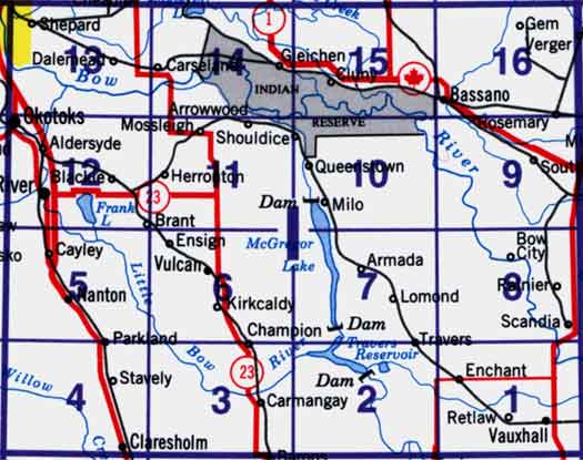
82I - Gleichen, 82I01 - Vauxhall, 82I02 - Travers, 82I03 - Carmangay, 82I04 - Claresholm, 82I05 - Nanton, 82I06 - Vulcan, 82I07 - Mcgregor Lake, 82I08 - Scandia, 82I09 - Cassils, 82I10 - Queenstown, 82I11 - Arrowwood, 82I12 - High River, 82I13 - Dalemead, 82I14 - Gleichen, 82I15 - Cluny, 82I16 - Bassano