Home > Maps > Canadian Topographic Maps

Click on the Province or Territory name or the picture below for a more detailed index of the Topographic Maps
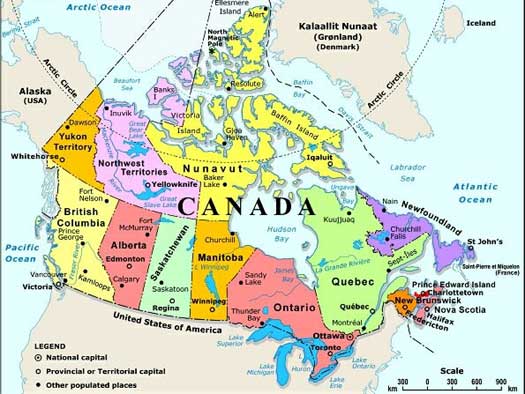

| British Columbia | Alberta | Saskatchewan | Manitoba | Ontario |

| Quebec | Newfoundland and Labrador | Nova Scotia | New Brunswick | Prince Edward Island |

| Nunavut | Yukon | Northwest Territories |

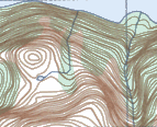
Canadian topographic maps (also known as "topo maps") come in two scales. The 1:50,000 scale topo map is the most detailed scale and covers an area of about 25 km by 40 km. Its high level of detail makes this scale topo map ideal for recreational activities, such as hiking, walking and bicycling. Accurately shown are hills, valleys, lakes, rivers, wooded areas and all man-made features such as buildings, powerlines, roads, dams and cut lines.

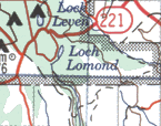
The 1:250,000 scale topographic map is more of an access map, for use in a vehicle than on foot. Each map sheet covers approximately 100 km by 160 km, the same area of land as 16 of the larger 1:50,000 scale maps. These topographic maps have gained popularity, not only for their detailed overview of a large area, but also as an excellent road map for exploring the back roads.

Topographic Map Names:
  • The names of topographic maps do not necessarily mean that the whole feature the map is named for is centered or completely shown on the map.
  • For example, map 83O07-Slave Lake - 1:50,000 scale, does not show the complete lake. Other maps will be required for complete lake coverage.
1:250,000 Scale Topographic Maps

  • Smaller scale map: covers more area in less detail
  • Covers an area approximately 100 km by 160 km
  • Covers same area of land as 16 of the 1:50,000 scale maps
  • Good overall view; ideal for travelling on backroads
1:250 000

1:250,000 Scale Map

1:50,000 Scale Topographic Maps

  • Larger scale map: covers less area in more detail
  • Covers an area approximately 25 km by 40 km
  • Ideal for recreational activities such as hiking, walking and bicycling
  • Natural features shown: hills, valleys, lakes, rivers, wooded areas
  • Man-made features shown: buildings, powerlines, roads, dams, cut lines
  • Contour intervals vary from map to map
1:50 000

1:50,000 Scale Map

The National Topographic System (NTS) of Canada

The area covered by a given map sheet is determined by its latitude and longitude. Because of the standard NTS numbering system, knowing the map number allows you to quickly identify adjacent maps.
how the NTS grid works
1:250,000 Scale Topographic Maps Numbering System
  • NTS Grid Numbering System format: Number followed by a Letter
  • Letters range from A through P
  • Examples of numbering: 12A, 115P, 83H
  • Each 1:250,000 map is divided into 16 segments numbered 1-16
1:50,000 Scale Topographic Maps
  • NTS Grid Numbering System format: Number, Letter followed by another Number ranging between 1-16
  • A 1:50,000 scale map is one of the 16 segments of the 1:250, 000 scale maps
  • Examples of numbering: 12A01, 115P16, 83H10
Sort By:
Page of 3
This easy to read Alberta Road Map showing towns and cities and highway numbers, with mileages, campgrounds and points of interest.  It also includes insets of major towns and cities, as well as an inset of the Northwest Territories. 001K - TREPASSEY - Topographic Map. Includes contour lines, water bodies, roads, population centers, treed areas, etc. Printed topo maps are great for recreational activities such as hiking, camping, biking or fishing. Topographic maps have lat and longs 001K11 - TREPASSEY - Topographic Map
Alberta Large Print Road Map. This easy to read Alberta Road Map showing towns and cities and highway numbers, with mileages, campgrounds and points of interest.  It also includes insets of major towns and cities, as well as an inset of the Northwest Territories. The Canadian 1:250,000 scale paper topographic map series also known as topo or topographical maps is very useful for providing an overview of an area.  These paper or laminated maps include contour lines, water bodies, roads, population centres, treed areas, etc. Printed topo maps are great for recreational activities such as hiking, camping, biking or fishing.  Topographic maps have latitude and longitude and UTM coordinates. Topo maps can be used with a compass or a GPS unit.  Canadian topographical paper maps can be laminated - makes map waterproof - for an additional charge. As the most detailed country-wide map series, the 1:50,000 paper topographic series also known as topo or topographical is ideal for any purpose that requires good detail of an area.  These topographical paper maps include contour lines, water bodies, roads, trails, population centres, treed areas, etc. Printed Topo maps are great for recreational activities such as hiking, camping, biking or fishing.  Topographic maps have latitude and longitute and UTM coordinates. Topo paper maps can be used with a compass or a GPS unit. Printed Canadian topographical maps can be laminated - makes map waterproof - for an additional charge.
031L16 - LA SAIRS - Topographic Map 053K11 - EDMUND LAKE - Topographic Map 074H06 - RUSSELL LAKE - Topographic Map
As the most detailed country-wide map series, the 1:50,000 paper topographic series also known as topo or topographical is ideal for any purpose that requires good detail of an area.  These topographical paper maps include contour lines, water bodies, roads, trails, population centres, treed areas, etc. Printed Topo maps are great for recreational activities such as hiking, camping, biking or fishing.  Topographic maps have latitude and longitute and UTM coordinates. Topo paper maps can be used with a compass or a GPS unit. Printed Canadian topographical maps can be laminated - makes map waterproof - for an additional charge. As the most detailed country-wide map series, the 1:50,000 paper topographic series also known as topo or topographical is ideal for any purpose that requires good detail of an area.  These topographical paper maps include contour lines, water bodies, roads, trails, population centres, treed areas, etc. Printed Topo maps are great for recreational activities such as hiking, camping, biking or fishing.  Topographic maps have latitude and longitute and UTM coordinates. Topo paper maps can be used with a compass or a GPS unit. Printed Canadian topographical maps can be laminated - makes map waterproof - for an additional charge. As the most detailed country-wide map series, the 1:50,000 paper topographic series also known as topo or topographical is ideal for any purpose that requires good detail of an area.  These topographical paper maps include contour lines, water bodies, roads, trails, population centres, treed areas, etc. Printed Topo maps are great for recreational activities such as hiking, camping, biking or fishing.  Topographic maps have latitude and longitute and UTM coordinates. Topo paper maps can be used with a compass or a GPS unit. Printed Canadian topographical maps can be laminated - makes map waterproof - for an additional charge.
082O11 - BURNT TIMBER CREEK - Topographic Map. Shows highway 40. Part of the Ya Ha Tinda area. As the most detailed country-wide map series, the 1:50,000 paper topographic series also known as topo or topographical is ideal for any purpose that requires g 082P - DRUMHELLER - Topographic Map 115P12 - GRAVEL CREEK - Topographic Map
082O11 - BURNT TIMBER CREEK - Topographic Map. Shows highway 40. Part of the Ya Ha Tinda area. As the most detailed country-wide map series, the 1:50,000 paper topographic series also known as topo or topographical is ideal for any purpose that requires good detail of an area.  These topographical paper maps include contour lines, water bodies, roads, trails, population centres, treed areas, etc. Printed Topo maps are great for recreational activities such as hiking, camping, biking or fishing.  Topographic maps have latitude and longitute and UTM coordinates. Topo paper maps can be used with a compass or a GPS unit. Printed Canadian topographical maps can be laminated - makes map waterproof - for an additional charge. The Canadian 1:250,000 scale paper topographic map series also known as topo or topographical maps is very useful for providing an overview of an area.  These paper or laminated maps include contour lines, water bodies, roads, population centres, treed areas, etc. Printed topo maps are great for recreational activities such as hiking, camping, biking or fishing.  Topographic maps have latitude and longitute and UTM coordinates. Topo maps can be used with a compass or a GPS unit.  Canadian topographical paper maps can be laminated - makes map waterproof - for an additional charge. As the most detailed country-wide map series, the 1:50,000 paper topographic series also known as topo or topographical is ideal for any purpose that requires good detail of an area.  These topographical paper maps include contour lines, water bodies, roads, trails, population centres, treed areas, etc. Printed Topo maps are great for recreational activities such as hiking, camping, biking or fishing.  Topographic maps have latitude and longitute and UTM coordinates. Topo paper maps can be used with a compass or a GPS unit. Printed Canadian topographical maps can be laminated - makes map waterproof - for an additional charge.
AB072E - FOREMOST - Topographic Map. The Alberta 1:250,000 scale paper topographic map series is part of the Alberta Environment & Parks Map Series. They are also referred to as topo or topographical maps is very useful for providing an overview of an are AB072L - MEDICINE HAT - Topographic Map. The Alberta 1:250,000 scale paper topographic map series is part of the Alberta Environment & Parks Map Series. They are also referred to as topo or topographical maps is very useful for providing an overview of a AB072M - OYEN - Topographic Map. The Alberta 1:250,000 scale paper topographic map series is part of the Alberta Environment & Parks Map Series. They are also referred to as topo or topographical maps is very useful for providing an overview of a
AB072E - FOREMOST - Topographic Map. The Alberta 1:250,000 scale paper topographic map series is part of the Alberta Environment & Parks Map Series. They are also referred to as topo or topographical maps is very useful for providing an overview of an area.  Features includes include contours or elevations, lakes and rivers, roads, cities, towns, villages, parks, first nation reserves, military bases, vegetation and more. Printed topo maps are great for recreational activities such as hiking, camping, biking or fishing.  Topographic maps have latitude / longitude and UTM coordinates. Topo maps can be used with a compass or a GPS unit. These Alberta topographical maps are available as a paper or be laminated, making the map waterproof - for an additional charge. AB072L - MEDICINE HAT - Topographic Map. The Alberta 1:250,000 scale paper topographic map series is part of the Alberta Environment & Parks Map Series. They are also referred to as topo or topographical maps is very useful for providing an overview of an area.  Features includes include contours or elevations, lakes and rivers, roads, cities, towns, villages, parks, first nation reserves, military bases, vegetation and more. Printed topo maps are great for recreational activities such as hiking, camping, biking or fishing.  Topographic maps have latitude / longitude and UTM coordinates. Topo maps can be used with a compass or a GPS unit. These Alberta topographical maps are available as a paper or be laminated, making the map waterproof - for an additional charge. AB072M - OYEN - Topographic Map. The Alberta 1:250,000 scale paper topographic map series is part of the Alberta Environment & Parks Map Series. They are also referred to as topo or topographical maps is very useful for providing an overview of an area.  Features includes include contours or elevations, lakes and rivers, roads, cities, towns, villages, parks, first nation reserves, military bases, vegetation and more. Printed topo maps are great for recreational activities such as hiking, camping, biking or fishing.  Topographic maps have latitude / longitude and UTM coordinates. Topo maps can be used with a compass or a GPS unit. These Alberta topographical maps are available as a paper or be laminated, making the map waterproof - for an additional charge.
AB073D - WAINWRIGHT - Topographic Map. The Alberta 1:250,000 scale paper topographic map series is part of the Alberta Environment & Parks Map Series. They are also referred to as topo or topographical maps is very useful for providing an overview of a AB073E - VERMILION - Topographic Map. The Alberta 1:250,000 scale paper topographic map series is part of the Alberta Environment & Parks Map Series. They are also referred to as topo or topographical maps is very useful for providing an overview of a AB073L - SAND RIVER - Topographic Map. The Alberta 1:250,000 scale paper topographic map series is part of the Alberta Environment & Parks Map Series. They are also referred to as topo or topographical maps is very useful for providing an overview of an a
AB073D - WAINWRIGHT - Topographic Map. The Alberta 1:250,000 scale paper topographic map series is part of the Alberta Environment & Parks Map Series. They are also referred to as topo or topographical maps is very useful for providing an overview of an area.  Features includes include contours or elevations, lakes and rivers, roads, cities, towns, villages, parks, first nation reserves, military bases, vegetation and more. Printed topo maps are great for recreational activities such as hiking, camping, biking or fishing.  Topographic maps have latitude / longitude and UTM coordinates. Topo maps can be used with a compass or a GPS unit. These Alberta topographical maps are available as a paper or be laminated, making the map waterproof - for an additional charge. AB073E - VERMILION - Topographic Map. The Alberta 1:250,000 scale paper topographic map series is part of the Alberta Environment & Parks Map Series. They are also referred to as topo or topographical maps is very useful for providing an overview of an area.  Features includes include contours or elevations, lakes and rivers, roads, cities, towns, villages, parks, first nation reserves, military bases, vegetation and more. Printed topo maps are great for recreational activities such as hiking, camping, biking or fishing.  Topographic maps have latitude / longitude and UTM coordinates. Topo maps can be used with a compass or a GPS unit. These Alberta topographical maps are available as a paper or be laminated, making the map waterproof - for an additional charge. AB073L - SAND RIVER - Topographic Map. The Alberta 1:250,000 scale paper topographic map series is part of the Alberta Environment & Parks Map Series. They are also referred to as topo or topographical maps is very useful for providing an overview of an area.  Features includes include contours or elevations, lakes and rivers, roads, cities, towns, villages, parks, first nation reserves, military bases, vegetation and more. Printed topo maps are great for recreational activities such as hiking, camping, biking or fishing.  Topographic maps have latitude / longitude and UTM coordinates. Topo maps can be used with a compass or a GPS unit. These Alberta topographical maps are available as a paper or be laminated, making the map waterproof - for an additional charge.
AB073M - WINEFRED LAKE - Topographic Map. The Alberta 1:250,000 scale paper topographic map series is part of the Alberta Environment & Parks Map Series. They are also referred to as topo or topographical maps is very useful for providing an overview of a AB074D - WATERWAYS - Topographic Map. The Alberta 1:250,000 scale paper topographic map series is part of the Alberta Environment & Parks Map Series. They are also referred to as topo or topographical maps is very useful for providing an overview of a AB074E - BITUMOUNT - Topographic Map. The Alberta 1:250,000 scale paper topographic map series is part of the Alberta Environment & Parks Map Series. They are also referred to as topo or topographical maps is very useful for providing an overview of a
AB073M - WINEFRED LAKE - Topographic Map. The Alberta 1:250,000 scale paper topographic map series is part of the Alberta Environment & Parks Map Series. They are also referred to as topo or topographical maps is very useful for providing an overview of an area.  Features includes include contours or elevations, lakes and rivers, roads, cities, towns, villages, parks, first nation reserves, military bases, vegetation and more. Printed topo maps are great for recreational activities such as hiking, camping, biking or fishing.  Topographic maps have latitude / longitude and UTM coordinates. Topo maps can be used with a compass or a GPS unit. These Alberta topographical maps are available as a paper or be laminated, making the map waterproof - for an additional charge. AB074D - WATERWAYS - Topographic Map. The Alberta 1:250,000 scale paper topographic map series is part of the Alberta Environment & Parks Map Series. They are also referred to as topo or topographical maps is very useful for providing an overview of an area.  Features includes include contours or elevations, lakes and rivers, roads, cities, towns, villages, parks, first nation reserves, military bases, vegetation and more. Printed topo maps are great for recreational activities such as hiking, camping, biking or fishing.  Topographic maps have latitude / longitude and UTM coordinates. Topo maps can be used with a compass or a GPS unit. These Alberta topographical maps are available as a paper or be laminated, making the map waterproof - for an additional charge. AB074E - BITUMOUNT - Topographic Map. The Alberta 1:250,000 scale paper topographic map series is part of the Alberta Environment & Parks Map Series. They are also referred to as topo or topographical maps is very useful for providing an overview of an area.  Features includes include contours or elevations, lakes and rivers, roads, cities, towns, villages, parks, first nation reserves, military bases, vegetation and more. Printed topo maps are great for recreational activities such as hiking, camping, biking or fishing.  Topographic maps have latitude / longitude and UTM coordinates. Topo maps can be used with a compass or a GPS unit. These Alberta topographical maps are available as a paper or be laminated, making the map waterproof - for an additional charge.
AB074L - FORT CHIPEWYAN- Topographic Map. The Alberta 1:250,000 scale paper topographic map series is part of the Alberta Environment & Parks Map Series. They are also referred to as topo or topographical maps is very useful for providing an overview of a AB074M - FITZGERALD - Topographic Map. The Alberta 1:250,000 scale paper topographic map series is part of the Alberta Environment & Parks Map Series. They are also referred to as topo or topographical maps is very useful for providing an overview of a AB082G - FERNIE - Topographic Map. The Alberta 1:250,000 scale paper topographic map series is part of the Alberta Environment & Parks Map Series. They are also referred to as topo or topographical maps is very useful for providing an overview of a
AB074L - FORT CHIPEWYAN  - Topographic Map. The Alberta 1:250,000 scale paper topographic map series is part of the Alberta Environment & Parks Map Series. They are also referred to as topo or topographical maps is very useful for providing an overview of an area.  Features includes include contours or elevations, lakes and rivers, roads, cities, towns, villages, parks, first nation reserves, military bases, vegetation and more. Printed topo maps are great for recreational activities such as hiking, camping, biking or fishing.  Topographic maps have latitude / longitude and UTM coordinates. Topo maps can be used with a compass or a GPS unit. These Alberta topographical maps are available as a paper or be laminated, making the map waterproof - for an additional charge. AB074M - FITZGERALD - Topographic Map. The Alberta 1:250,000 scale paper topographic map series is part of the Alberta Environment & Parks Map Series. They are also referred to as topo or topographical maps is very useful for providing an overview of an area.  Features includes include contours or elevations, lakes and rivers, roads, cities, towns, villages, parks, first nation reserves, military bases, vegetation and more. Printed topo maps are great for recreational activities such as hiking, camping, biking or fishing.  Topographic maps have latitude / longitude and UTM coordinates. Topo maps can be used with a compass or a GPS unit. These Alberta topographical maps are available as a paper or be laminated, making the map waterproof - for an additional charge. AB082G - FERNIE - Topographic Map. The Alberta 1:250,000 scale paper topographic map series is part of the Alberta Environment & Parks Map Series. They are also referred to as topo or topographical maps is very useful for providing an overview of an area.  Features includes include contours or elevations, lakes and rivers, roads, cities, towns, villages, parks, first nation reserves, military bases, vegetation and more. Printed topo maps are great for recreational activities such as hiking, camping, biking or fishing.  Topographic maps have latitude / longitude and UTM coordinates. Topo maps can be used with a compass or a GPS unit. These Alberta topographical maps are available as a paper or be laminated, making the map waterproof - for an additional charge.
AB082H - LETHBRIDGE - Topographic Map. The Alberta 1:250,000 scale paper topographic map series is part of the Alberta Environment & Parks Map Series. They are also referred to as topo or topographical maps is very useful for providing an overview of a AB082I - GLEICHEN - Topographic Map. The Alberta 1:250,000 scale paper topographic map series is part of the Alberta Environment & Parks Map Series. They are also referred to as topo or topographical maps is very useful for providing an overview of a AB082J - KANANASKIS LAKES - Topographic Map. The Alberta 1:250,000 scale paper topographic map series is part of the Alberta Environment & Parks Map Series. They are also referred to as topo or topographical maps is very useful for providing an overview o
AB082H - LETHBRIDGE - Topographic Map. The Alberta 1:250,000 scale paper topographic map series is part of the Alberta Environment & Parks Map Series. They are also referred to as topo or topographical maps is very useful for providing an overview of an area.  Features includes include contours or elevations, lakes and rivers, roads, cities, towns, villages, parks, first nation reserves, military bases, vegetation and more. Printed topo maps are great for recreational activities such as hiking, camping, biking or fishing.  Topographic maps have latitude / longitude and UTM coordinates. Topo maps can be used with a compass or a GPS unit. These Alberta topographical maps are available as a paper or be laminated, making the map waterproof - for an additional charge. AB082I - GLEICHEN - Topographic Map. The Alberta 1:250,000 scale paper topographic map series is part of the Alberta Environment & Parks Map Series. They are also referred to as topo or topographical maps is very useful for providing an overview of an area.  Features includes include contours or elevations, lakes and rivers, roads, cities, towns, villages, parks, first nation reserves, military bases, vegetation and more. Printed topo maps are great for recreational activities such as hiking, camping, biking or fishing.  Topographic maps have latitude / longitude and UTM coordinates. Topo maps can be used with a compass or a GPS unit. These Alberta topographical maps are available as a paper or be laminated, making the map waterproof - for an additional charge. AB082J - KANANASKIS LAKES - Topographic Map. The Alberta 1:250,000 scale paper topographic map series is part of the Alberta Environment & Parks Map Series. They are also referred to as topo or topographical maps is very useful for providing an overview of an area.  Features includes include contours or elevations, lakes and rivers, roads, cities, towns, villages, parks, first nation reserves, military bases, vegetation and more. Printed topo maps are great for recreational activities such as hiking, camping, biking or fishing.  Topographic maps have latitude / longitude and UTM coordinates. Topo maps can be used with a compass or a GPS unit. These Alberta topographical maps are available as a paper or be laminated, making the map waterproof - for an additional charge.
AB082N - GOLDEN - Topographic Map. The Alberta 1:250,000 scale paper topographic map series is part of the Alberta Environment & Parks Map Series. They are also referred to as topo or topographical maps is very useful for providing an overview o AB082O - CALGARY - Topographic Map. The Alberta 1:250,000 scale paper topographic map series is part of the Alberta Environment & Parks Map Series. They are also referred to as topo or topographical maps is very useful for providing an overview o AB082P - DRUMHELLER - Topographic Map. The Alberta 1:250,000 scale paper topographic map series is part of the Alberta Environment & Parks Map Series. They are also referred to as topo or topographical maps is very useful for providing an overview o
AB082N - GOLDEN - Topographic Map. The Alberta 1:250,000 scale paper topographic map series is part of the Alberta Environment & Parks Map Series. They are also referred to as topo or topographical maps is very useful for providing an overview of an area.  Features includes include contours or elevations, lakes and rivers, roads, cities, towns, villages, parks, first nation reserves, military bases, vegetation and more. Printed topo maps are great for recreational activities such as hiking, camping, biking or fishing.  Topographic maps have latitude / longitude and UTM coordinates. Topo maps can be used with a compass or a GPS unit. These Alberta topographical maps are available as a paper or be laminated, making the map waterproof - for an additional charge. AB082O - CALGARY - Topographic Map. The Alberta 1:250,000 scale paper topographic map series is part of the Alberta Environment & Parks Map Series. They are also referred to as topo or topographical maps is very useful for providing an overview of an area.  Features includes include contours or elevations, lakes and rivers, roads, cities, towns, villages, parks, first nation reserves, military bases, vegetation and more. Printed topo maps are great for recreational activities such as hiking, camping, biking or fishing.  Topographic maps have latitude / longitude and UTM coordinates. Topo maps can be used with a compass or a GPS unit. These Alberta topographical maps are available as a paper or be laminated, making the map waterproof - for an additional charge. AB082P - DRUMHELLER - Topographic Map. The Alberta 1:250,000 scale paper topographic map series is part of the Alberta Environment & Parks Map Series. They are also referred to as topo or topographical maps is very useful for providing an overview of an area.  Features includes include contours or elevations, lakes and rivers, roads, cities, towns, villages, parks, first nation reserves, military bases, vegetation and more. Printed topo maps are great for recreational activities such as hiking, camping, biking or fishing.  Topographic maps have latitude / longitude and UTM coordinates. Topo maps can be used with a compass or a GPS unit. These Alberta topographical maps are available as a paper or be laminated, making the map waterproof - for an additional charge.
AB083A - RED DEER - Topographic Map. The Alberta 1:250,000 scale paper topographic map series is part of the Alberta Environment & Parks Map Series. They are also referred to as topo or topographical maps is very useful for providing an overview o AB083B - ROCKY MOUNTAIN HOUSE - Topographic Map. The Alberta 1:250,000 scale paper topographic map series is part of the Alberta Environment & Parks Map Series. They are also referred to as topo or topographical maps is very useful for providing an overvi AB083C - BRAZEAU - Topographic Map. The Alberta 1:250,000 scale paper topographic map series is part of the Alberta Environment & Parks Map Series. They are also referred to as topo or topographical maps is very useful for providing an overvi
AB083A - RED DEER - Topographic Map. The Alberta 1:250,000 scale paper topographic map series is part of the Alberta Environment & Parks Map Series. They are also referred to as topo or topographical maps is very useful for providing an overview of an area.  Features includes include contours or elevations, lakes and rivers, roads, cities, towns, villages, parks, first nation reserves, military bases, vegetation and more. Printed topo maps are great for recreational activities such as hiking, camping, biking or fishing.  Topographic maps have latitude / longitude and UTM coordinates. Topo maps can be used with a compass or a GPS unit. These Alberta topographical maps are available as a paper or be laminated, making the map waterproof - for an additional charge. AB083B - ROCKY MOUNTAIN HOUSE - Topographic Map. The Alberta 1:250,000 scale paper topographic map series is part of the Alberta Environment & Parks Map Series. They are also referred to as topo or topographical maps is very useful for providing an overview of an area.  Features includes include contours or elevations, lakes and rivers, roads, cities, towns, villages, parks, first nation reserves, military bases, vegetation and more. Printed topo maps are great for recreational activities such as hiking, camping, biking or fishing.  Topographic maps have latitude / longitude and UTM coordinates. Topo maps can be used with a compass or a GPS unit. These Alberta topographical maps are available as a paper or be laminated, making the map waterproof - for an additional charge. AB083C - BRAZEAU - Topographic Map. The Alberta 1:250,000 scale paper topographic map series is part of the Alberta Environment & Parks Map Series. They are also referred to as topo or topographical maps is very useful for providing an overview of an area.  Features includes include contours or elevations, lakes and rivers, roads, cities, towns, villages, parks, first nation reserves, military bases, vegetation and more. Printed topo maps are great for recreational activities such as hiking, camping, biking or fishing.  Topographic maps have latitude / longitude and UTM coordinates. Topo maps can be used with a compass or a GPS unit. These Alberta topographical maps are available as a paper or be laminated, making the map waterproof - for an additional charge.