Home > Maps > Canadian Topographic Maps > Alberta Topographic Maps

Canadian Topographic Maps - Alberta


1:250 000 and 1:50 000 scale NTS Maps

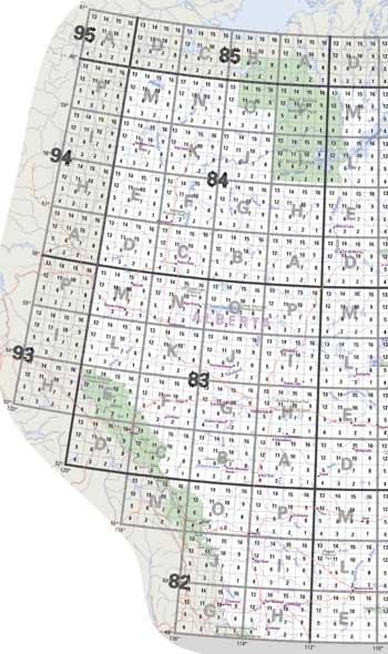
Click on an area of the map below to zoom in on each topo map index.

We have all the Alberta 1:250 000 scale and 1:50 000 scale topo maps in stock. Click on the topo map index below to locate the Alberta topographical maps you need.
Back to the Canada Topo Maps Index.

Sort By:
Page of 3
This easy to read Alberta Road Map showing towns and cities and highway numbers, with mileages, campgrounds and points of interest.  It also includes insets of major towns and cities, as well as an inset of the Northwest Territories. AB072E - FOREMOST - Topographic Map. The Alberta 1:250,000 scale paper topographic map series is part of the Alberta Environment & Parks Map Series. They are also referred to as topo or topographical maps is very useful for providing an overview of an are AB072L - MEDICINE HAT - Topographic Map. The Alberta 1:250,000 scale paper topographic map series is part of the Alberta Environment & Parks Map Series. They are also referred to as topo or topographical maps is very useful for providing an overview of a
Alberta Large Print Road Map. This easy to read Alberta Road Map showing towns and cities and highway numbers, with mileages, campgrounds and points of interest.  It also includes insets of major towns and cities, as well as an inset of the Northwest Territories. AB072E - FOREMOST - Topographic Map. The Alberta 1:250,000 scale paper topographic map series is part of the Alberta Environment & Parks Map Series. They are also referred to as topo or topographical maps is very useful for providing an overview of an area.  Features includes include contours or elevations, lakes and rivers, roads, cities, towns, villages, parks, first nation reserves, military bases, vegetation and more. Printed topo maps are great for recreational activities such as hiking, camping, biking or fishing.  Topographic maps have latitude / longitude and UTM coordinates. Topo maps can be used with a compass or a GPS unit. These Alberta topographical maps are available as a paper or be laminated, making the map waterproof - for an additional charge. AB072L - MEDICINE HAT - Topographic Map. The Alberta 1:250,000 scale paper topographic map series is part of the Alberta Environment & Parks Map Series. They are also referred to as topo or topographical maps is very useful for providing an overview of an area.  Features includes include contours or elevations, lakes and rivers, roads, cities, towns, villages, parks, first nation reserves, military bases, vegetation and more. Printed topo maps are great for recreational activities such as hiking, camping, biking or fishing.  Topographic maps have latitude / longitude and UTM coordinates. Topo maps can be used with a compass or a GPS unit. These Alberta topographical maps are available as a paper or be laminated, making the map waterproof - for an additional charge.
AB072M - OYEN - Topographic Map. The Alberta 1:250,000 scale paper topographic map series is part of the Alberta Environment & Parks Map Series. They are also referred to as topo or topographical maps is very useful for providing an overview of a AB073D - WAINWRIGHT - Topographic Map. The Alberta 1:250,000 scale paper topographic map series is part of the Alberta Environment & Parks Map Series. They are also referred to as topo or topographical maps is very useful for providing an overview of a AB073E - VERMILION - Topographic Map. The Alberta 1:250,000 scale paper topographic map series is part of the Alberta Environment & Parks Map Series. They are also referred to as topo or topographical maps is very useful for providing an overview of a
AB072M - OYEN - Topographic Map. The Alberta 1:250,000 scale paper topographic map series is part of the Alberta Environment & Parks Map Series. They are also referred to as topo or topographical maps is very useful for providing an overview of an area.  Features includes include contours or elevations, lakes and rivers, roads, cities, towns, villages, parks, first nation reserves, military bases, vegetation and more. Printed topo maps are great for recreational activities such as hiking, camping, biking or fishing.  Topographic maps have latitude / longitude and UTM coordinates. Topo maps can be used with a compass or a GPS unit. These Alberta topographical maps are available as a paper or be laminated, making the map waterproof - for an additional charge. AB073D - WAINWRIGHT - Topographic Map. The Alberta 1:250,000 scale paper topographic map series is part of the Alberta Environment & Parks Map Series. They are also referred to as topo or topographical maps is very useful for providing an overview of an area.  Features includes include contours or elevations, lakes and rivers, roads, cities, towns, villages, parks, first nation reserves, military bases, vegetation and more. Printed topo maps are great for recreational activities such as hiking, camping, biking or fishing.  Topographic maps have latitude / longitude and UTM coordinates. Topo maps can be used with a compass or a GPS unit. These Alberta topographical maps are available as a paper or be laminated, making the map waterproof - for an additional charge. AB073E - VERMILION - Topographic Map. The Alberta 1:250,000 scale paper topographic map series is part of the Alberta Environment & Parks Map Series. They are also referred to as topo or topographical maps is very useful for providing an overview of an area.  Features includes include contours or elevations, lakes and rivers, roads, cities, towns, villages, parks, first nation reserves, military bases, vegetation and more. Printed topo maps are great for recreational activities such as hiking, camping, biking or fishing.  Topographic maps have latitude / longitude and UTM coordinates. Topo maps can be used with a compass or a GPS unit. These Alberta topographical maps are available as a paper or be laminated, making the map waterproof - for an additional charge.
AB073L - SAND RIVER - Topographic Map. The Alberta 1:250,000 scale paper topographic map series is part of the Alberta Environment & Parks Map Series. They are also referred to as topo or topographical maps is very useful for providing an overview of an a AB073M - WINEFRED LAKE - Topographic Map. The Alberta 1:250,000 scale paper topographic map series is part of the Alberta Environment & Parks Map Series. They are also referred to as topo or topographical maps is very useful for providing an overview of a AB074D - WATERWAYS - Topographic Map. The Alberta 1:250,000 scale paper topographic map series is part of the Alberta Environment & Parks Map Series. They are also referred to as topo or topographical maps is very useful for providing an overview of a
AB073L - SAND RIVER - Topographic Map. The Alberta 1:250,000 scale paper topographic map series is part of the Alberta Environment & Parks Map Series. They are also referred to as topo or topographical maps is very useful for providing an overview of an area.  Features includes include contours or elevations, lakes and rivers, roads, cities, towns, villages, parks, first nation reserves, military bases, vegetation and more. Printed topo maps are great for recreational activities such as hiking, camping, biking or fishing.  Topographic maps have latitude / longitude and UTM coordinates. Topo maps can be used with a compass or a GPS unit. These Alberta topographical maps are available as a paper or be laminated, making the map waterproof - for an additional charge. AB073M - WINEFRED LAKE - Topographic Map. The Alberta 1:250,000 scale paper topographic map series is part of the Alberta Environment & Parks Map Series. They are also referred to as topo or topographical maps is very useful for providing an overview of an area.  Features includes include contours or elevations, lakes and rivers, roads, cities, towns, villages, parks, first nation reserves, military bases, vegetation and more. Printed topo maps are great for recreational activities such as hiking, camping, biking or fishing.  Topographic maps have latitude / longitude and UTM coordinates. Topo maps can be used with a compass or a GPS unit. These Alberta topographical maps are available as a paper or be laminated, making the map waterproof - for an additional charge. AB074D - WATERWAYS - Topographic Map. The Alberta 1:250,000 scale paper topographic map series is part of the Alberta Environment & Parks Map Series. They are also referred to as topo or topographical maps is very useful for providing an overview of an area.  Features includes include contours or elevations, lakes and rivers, roads, cities, towns, villages, parks, first nation reserves, military bases, vegetation and more. Printed topo maps are great for recreational activities such as hiking, camping, biking or fishing.  Topographic maps have latitude / longitude and UTM coordinates. Topo maps can be used with a compass or a GPS unit. These Alberta topographical maps are available as a paper or be laminated, making the map waterproof - for an additional charge.
AB074E - BITUMOUNT - Topographic Map. The Alberta 1:250,000 scale paper topographic map series is part of the Alberta Environment & Parks Map Series. They are also referred to as topo or topographical maps is very useful for providing an overview of a AB074L - FORT CHIPEWYAN- Topographic Map. The Alberta 1:250,000 scale paper topographic map series is part of the Alberta Environment & Parks Map Series. They are also referred to as topo or topographical maps is very useful for providing an overview of a AB074M - FITZGERALD - Topographic Map. The Alberta 1:250,000 scale paper topographic map series is part of the Alberta Environment & Parks Map Series. They are also referred to as topo or topographical maps is very useful for providing an overview of a
AB074E - BITUMOUNT - Topographic Map. The Alberta 1:250,000 scale paper topographic map series is part of the Alberta Environment & Parks Map Series. They are also referred to as topo or topographical maps is very useful for providing an overview of an area.  Features includes include contours or elevations, lakes and rivers, roads, cities, towns, villages, parks, first nation reserves, military bases, vegetation and more. Printed topo maps are great for recreational activities such as hiking, camping, biking or fishing.  Topographic maps have latitude / longitude and UTM coordinates. Topo maps can be used with a compass or a GPS unit. These Alberta topographical maps are available as a paper or be laminated, making the map waterproof - for an additional charge. AB074L - FORT CHIPEWYAN  - Topographic Map. The Alberta 1:250,000 scale paper topographic map series is part of the Alberta Environment & Parks Map Series. They are also referred to as topo or topographical maps is very useful for providing an overview of an area.  Features includes include contours or elevations, lakes and rivers, roads, cities, towns, villages, parks, first nation reserves, military bases, vegetation and more. Printed topo maps are great for recreational activities such as hiking, camping, biking or fishing.  Topographic maps have latitude / longitude and UTM coordinates. Topo maps can be used with a compass or a GPS unit. These Alberta topographical maps are available as a paper or be laminated, making the map waterproof - for an additional charge. AB074M - FITZGERALD - Topographic Map. The Alberta 1:250,000 scale paper topographic map series is part of the Alberta Environment & Parks Map Series. They are also referred to as topo or topographical maps is very useful for providing an overview of an area.  Features includes include contours or elevations, lakes and rivers, roads, cities, towns, villages, parks, first nation reserves, military bases, vegetation and more. Printed topo maps are great for recreational activities such as hiking, camping, biking or fishing.  Topographic maps have latitude / longitude and UTM coordinates. Topo maps can be used with a compass or a GPS unit. These Alberta topographical maps are available as a paper or be laminated, making the map waterproof - for an additional charge.
AB082G - FERNIE - Topographic Map. The Alberta 1:250,000 scale paper topographic map series is part of the Alberta Environment & Parks Map Series. They are also referred to as topo or topographical maps is very useful for providing an overview of a AB082H - LETHBRIDGE - Topographic Map. The Alberta 1:250,000 scale paper topographic map series is part of the Alberta Environment & Parks Map Series. They are also referred to as topo or topographical maps is very useful for providing an overview of a AB082I - GLEICHEN - Topographic Map. The Alberta 1:250,000 scale paper topographic map series is part of the Alberta Environment & Parks Map Series. They are also referred to as topo or topographical maps is very useful for providing an overview of a
AB082G - FERNIE - Topographic Map. The Alberta 1:250,000 scale paper topographic map series is part of the Alberta Environment & Parks Map Series. They are also referred to as topo or topographical maps is very useful for providing an overview of an area.  Features includes include contours or elevations, lakes and rivers, roads, cities, towns, villages, parks, first nation reserves, military bases, vegetation and more. Printed topo maps are great for recreational activities such as hiking, camping, biking or fishing.  Topographic maps have latitude / longitude and UTM coordinates. Topo maps can be used with a compass or a GPS unit. These Alberta topographical maps are available as a paper or be laminated, making the map waterproof - for an additional charge. AB082H - LETHBRIDGE - Topographic Map. The Alberta 1:250,000 scale paper topographic map series is part of the Alberta Environment & Parks Map Series. They are also referred to as topo or topographical maps is very useful for providing an overview of an area.  Features includes include contours or elevations, lakes and rivers, roads, cities, towns, villages, parks, first nation reserves, military bases, vegetation and more. Printed topo maps are great for recreational activities such as hiking, camping, biking or fishing.  Topographic maps have latitude / longitude and UTM coordinates. Topo maps can be used with a compass or a GPS unit. These Alberta topographical maps are available as a paper or be laminated, making the map waterproof - for an additional charge. AB082I - GLEICHEN - Topographic Map. The Alberta 1:250,000 scale paper topographic map series is part of the Alberta Environment & Parks Map Series. They are also referred to as topo or topographical maps is very useful for providing an overview of an area.  Features includes include contours or elevations, lakes and rivers, roads, cities, towns, villages, parks, first nation reserves, military bases, vegetation and more. Printed topo maps are great for recreational activities such as hiking, camping, biking or fishing.  Topographic maps have latitude / longitude and UTM coordinates. Topo maps can be used with a compass or a GPS unit. These Alberta topographical maps are available as a paper or be laminated, making the map waterproof - for an additional charge.
AB082J - KANANASKIS LAKES - Topographic Map. The Alberta 1:250,000 scale paper topographic map series is part of the Alberta Environment & Parks Map Series. They are also referred to as topo or topographical maps is very useful for providing an overview o AB082N - GOLDEN - Topographic Map. The Alberta 1:250,000 scale paper topographic map series is part of the Alberta Environment & Parks Map Series. They are also referred to as topo or topographical maps is very useful for providing an overview o AB082O - CALGARY - Topographic Map. The Alberta 1:250,000 scale paper topographic map series is part of the Alberta Environment & Parks Map Series. They are also referred to as topo or topographical maps is very useful for providing an overview o
AB082J - KANANASKIS LAKES - Topographic Map. The Alberta 1:250,000 scale paper topographic map series is part of the Alberta Environment & Parks Map Series. They are also referred to as topo or topographical maps is very useful for providing an overview of an area.  Features includes include contours or elevations, lakes and rivers, roads, cities, towns, villages, parks, first nation reserves, military bases, vegetation and more. Printed topo maps are great for recreational activities such as hiking, camping, biking or fishing.  Topographic maps have latitude / longitude and UTM coordinates. Topo maps can be used with a compass or a GPS unit. These Alberta topographical maps are available as a paper or be laminated, making the map waterproof - for an additional charge. AB082N - GOLDEN - Topographic Map. The Alberta 1:250,000 scale paper topographic map series is part of the Alberta Environment & Parks Map Series. They are also referred to as topo or topographical maps is very useful for providing an overview of an area.  Features includes include contours or elevations, lakes and rivers, roads, cities, towns, villages, parks, first nation reserves, military bases, vegetation and more. Printed topo maps are great for recreational activities such as hiking, camping, biking or fishing.  Topographic maps have latitude / longitude and UTM coordinates. Topo maps can be used with a compass or a GPS unit. These Alberta topographical maps are available as a paper or be laminated, making the map waterproof - for an additional charge. AB082O - CALGARY - Topographic Map. The Alberta 1:250,000 scale paper topographic map series is part of the Alberta Environment & Parks Map Series. They are also referred to as topo or topographical maps is very useful for providing an overview of an area.  Features includes include contours or elevations, lakes and rivers, roads, cities, towns, villages, parks, first nation reserves, military bases, vegetation and more. Printed topo maps are great for recreational activities such as hiking, camping, biking or fishing.  Topographic maps have latitude / longitude and UTM coordinates. Topo maps can be used with a compass or a GPS unit. These Alberta topographical maps are available as a paper or be laminated, making the map waterproof - for an additional charge.
AB082P - DRUMHELLER - Topographic Map. The Alberta 1:250,000 scale paper topographic map series is part of the Alberta Environment & Parks Map Series. They are also referred to as topo or topographical maps is very useful for providing an overview o AB083A - RED DEER - Topographic Map. The Alberta 1:250,000 scale paper topographic map series is part of the Alberta Environment & Parks Map Series. They are also referred to as topo or topographical maps is very useful for providing an overview o AB083B - ROCKY MOUNTAIN HOUSE - Topographic Map. The Alberta 1:250,000 scale paper topographic map series is part of the Alberta Environment & Parks Map Series. They are also referred to as topo or topographical maps is very useful for providing an overvi
AB082P - DRUMHELLER - Topographic Map. The Alberta 1:250,000 scale paper topographic map series is part of the Alberta Environment & Parks Map Series. They are also referred to as topo or topographical maps is very useful for providing an overview of an area.  Features includes include contours or elevations, lakes and rivers, roads, cities, towns, villages, parks, first nation reserves, military bases, vegetation and more. Printed topo maps are great for recreational activities such as hiking, camping, biking or fishing.  Topographic maps have latitude / longitude and UTM coordinates. Topo maps can be used with a compass or a GPS unit. These Alberta topographical maps are available as a paper or be laminated, making the map waterproof - for an additional charge. AB083A - RED DEER - Topographic Map. The Alberta 1:250,000 scale paper topographic map series is part of the Alberta Environment & Parks Map Series. They are also referred to as topo or topographical maps is very useful for providing an overview of an area.  Features includes include contours or elevations, lakes and rivers, roads, cities, towns, villages, parks, first nation reserves, military bases, vegetation and more. Printed topo maps are great for recreational activities such as hiking, camping, biking or fishing.  Topographic maps have latitude / longitude and UTM coordinates. Topo maps can be used with a compass or a GPS unit. These Alberta topographical maps are available as a paper or be laminated, making the map waterproof - for an additional charge. AB083B - ROCKY MOUNTAIN HOUSE - Topographic Map. The Alberta 1:250,000 scale paper topographic map series is part of the Alberta Environment & Parks Map Series. They are also referred to as topo or topographical maps is very useful for providing an overview of an area.  Features includes include contours or elevations, lakes and rivers, roads, cities, towns, villages, parks, first nation reserves, military bases, vegetation and more. Printed topo maps are great for recreational activities such as hiking, camping, biking or fishing.  Topographic maps have latitude / longitude and UTM coordinates. Topo maps can be used with a compass or a GPS unit. These Alberta topographical maps are available as a paper or be laminated, making the map waterproof - for an additional charge.
AB083C - BRAZEAU - Topographic Map. The Alberta 1:250,000 scale paper topographic map series is part of the Alberta Environment & Parks Map Series. They are also referred to as topo or topographical maps is very useful for providing an overvi AB083D - CANOE RIVER - Topographic Map. The Alberta 1:250,000 scale paper topographic map series is part of the Alberta Environment & Parks Map Series. They are also referred to as topo or topographical maps is very useful for providing an overvi AB083E - MOUNT ROBSON - Topographic Map. The Alberta 1:250,000 scale paper topographic map series is part of the Alberta Environment & Parks Map Series. They are also referred to as topo or topographical maps is very useful for providing an overvi
AB083C - BRAZEAU - Topographic Map. The Alberta 1:250,000 scale paper topographic map series is part of the Alberta Environment & Parks Map Series. They are also referred to as topo or topographical maps is very useful for providing an overview of an area.  Features includes include contours or elevations, lakes and rivers, roads, cities, towns, villages, parks, first nation reserves, military bases, vegetation and more. Printed topo maps are great for recreational activities such as hiking, camping, biking or fishing.  Topographic maps have latitude / longitude and UTM coordinates. Topo maps can be used with a compass or a GPS unit. These Alberta topographical maps are available as a paper or be laminated, making the map waterproof - for an additional charge. AB083D - CANOE RIVER - Topographic Map. The Alberta 1:250,000 scale paper topographic map series is part of the Alberta Environment & Parks Map Series. They are also referred to as topo or topographical maps is very useful for providing an overview of an area.  Features includes include contours or elevations, lakes and rivers, roads, cities, towns, villages, parks, first nation reserves, military bases, vegetation and more. Printed topo maps are great for recreational activities such as hiking, camping, biking or fishing.  Topographic maps have latitude / longitude and UTM coordinates. Topo maps can be used with a compass or a GPS unit. These Alberta topographical maps are available as a paper or be laminated, making the map waterproof - for an additional charge. AB083E - MOUNT ROBSON - Topographic Map. The Alberta 1:250,000 scale paper topographic map series is part of the Alberta Environment & Parks Map Series. They are also referred to as topo or topographical maps is very useful for providing an overview of an area.  Features includes include contours or elevations, lakes and rivers, roads, cities, towns, villages, parks, first nation reserves, military bases, vegetation and more. Printed topo maps are great for recreational activities such as hiking, camping, biking or fishing.  Topographic maps have latitude / longitude and UTM coordinates. Topo maps can be used with a compass or a GPS unit. These Alberta topographical maps are available as a paper or be laminated, making the map waterproof - for an additional charge.
AB083F - EDSON - Topographic Map. The Alberta 1:250,000 scale paper topographic map series is part of the Alberta Environment & Parks Map Series. They are also referred to as topo or topographical maps is very useful for providing an overvi AB083G - WABAMUN LAKE - Topographic Map. The Alberta 1:250,000 scale paper topographic map series is part of the Alberta Environment & Parks Map Series. They are also referred to as topo or topographical maps is very useful for providing an overvi AB083H - EDMONTON - Topographic Map. The Alberta 1:250,000 scale paper topographic map series is part of the Alberta Environment & Parks Map Series. They are also referred to as topo or topographical maps is very useful for providing an overvi
AB083F - EDSON - Topographic Map. The Alberta 1:250,000 scale paper topographic map series is part of the Alberta Environment & Parks Map Series. They are also referred to as topo or topographical maps is very useful for providing an overview of an area.  Features includes include contours or elevations, lakes and rivers, roads, cities, towns, villages, parks, first nation reserves, military bases, vegetation and more. Printed topo maps are great for recreational activities such as hiking, camping, biking or fishing.  Topographic maps have latitude / longitude and UTM coordinates. Topo maps can be used with a compass or a GPS unit. These Alberta topographical maps are available as a paper or be laminated, making the map waterproof - for an additional charge. AB083G - WABAMUN LAKE - Topographic Map. The Alberta 1:250,000 scale paper topographic map series is part of the Alberta Environment & Parks Map Series. They are also referred to as topo or topographical maps is very useful for providing an overview of an area.  Features includes include contours or elevations, lakes and rivers, roads, cities, towns, villages, parks, first nation reserves, military bases, vegetation and more. Printed topo maps are great for recreational activities such as hiking, camping, biking or fishing.  Topographic maps have latitude / longitude and UTM coordinates. Topo maps can be used with a compass or a GPS unit. These Alberta topographical maps are available as a paper or be laminated, making the map waterproof - for an additional charge. AB083H - EDMONTON - Topographic Map. The Alberta 1:250,000 scale paper topographic map series is part of the Alberta Environment & Parks Map Series. They are also referred to as topo or topographical maps is very useful for providing an overview of an area.  Features includes include contours or elevations, lakes and rivers, roads, cities, towns, villages, parks, first nation reserves, military bases, vegetation and more. Printed topo maps are great for recreational activities such as hiking, camping, biking or fishing.  Topographic maps have latitude / longitude and UTM coordinates. Topo maps can be used with a compass or a GPS unit. These Alberta topographical maps are available as a paper or be laminated, making the map waterproof - for an additional charge.
AB083I - TAWATINAW - Topographic Map. The Alberta 1:250,000 scale paper topographic map series is part of the Alberta Environment & Parks Map Series. They are also referred to as topo or topographical maps is very useful for providing an overvi AB083J - WHITECOURT - Topographic Map. The Alberta 1:250,000 scale paper topographic map series is part of the Alberta Environment & Parks Map Series. They are also referred to as topo or topographical maps is very useful for providing an overvi AB083K - IOSEGUN LAKE - Topographic Map. The Alberta 1:250,000 scale paper topographic map series is part of the Alberta Environment & Parks Map Series. They are also referred to as topo or topographical maps is very useful for providing an overview of an
AB083I - TAWATINAW - Topographic Map. The Alberta 1:250,000 scale paper topographic map series is part of the Alberta Environment & Parks Map Series. They are also referred to as topo or topographical maps is very useful for providing an overview of an area.  Features includes include contours or elevations, lakes and rivers, roads, cities, towns, villages, parks, first nation reserves, military bases, vegetation and more. Printed topo maps are great for recreational activities such as hiking, camping, biking or fishing.  Topographic maps have latitude / longitude and UTM coordinates. Topo maps can be used with a compass or a GPS unit. These Alberta topographical maps are available as a paper or be laminated, making the map waterproof - for an additional charge. AB083J - WHITECOURT - Topographic Map. The Alberta 1:250,000 scale paper topographic map series is part of the Alberta Environment & Parks Map Series. They are also referred to as topo or topographical maps is very useful for providing an overview of an area.  Features includes include contours or elevations, lakes and rivers, roads, cities, towns, villages, parks, first nation reserves, military bases, vegetation and more. Printed topo maps are great for recreational activities such as hiking, camping, biking or fishing.  Topographic maps have latitude / longitude and UTM coordinates. Topo maps can be used with a compass or a GPS unit. These Alberta topographical maps are available as a paper or be laminated, making the map waterproof - for an additional charge. AB083K - IOSEGUN LAKE - Topographic Map. The Alberta 1:250,000 scale paper topographic map series is part of the Alberta Environment & Parks Map Series. They are also referred to as topo or topographical maps is very useful for providing an overview of an area.  Features includes include contours or elevations, lakes and rivers, roads, cities, towns, villages, parks, first nation reserves, military bases, vegetation and more. Printed topo maps are great for recreational activities such as hiking, camping, biking or fishing.  Topographic maps have latitude / longitude and UTM coordinates. Topo maps can be used with a compass or a GPS unit. These Alberta topographical maps are available as a paper or be laminated, making the map waterproof - for an additional charge.