QUESTIONS? CALL OR TEXT! 1 (877) 921-6277 or (403) 266-2241
WE SHIP EVERYWHERE!


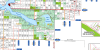
The Vulcan County Landownership Map is an essential, high-precision reference map designed for rural property owners, agricultural producers, land negotiators, real estate professionals, and outdoor enthusiasts operating within southern Alberta. Providing complete coverage of Vulcan County (Municipal District No. 2), this detailed regional map delivers clear, up-to-date surface land ownership records mapped across the Dominion Land Survey (DLS) system down to every quarter section ($1/4$ section).
Detailed Parcel Ownership: Every quarter section clearly displays the registered landowner's name, making it easy to identify property boundaries and landholdings throughout the municipal district.
Color-Coded Land Classifications: Distinct visual color coding instantly distinguishes between Crown (government-owned), Freehold (privately owned), and Crown Leased lands for clear boundary verification and legal land status checks.
Updated Rural Road Network: Features the most current transportation infrastructure, including major highways, secondary roads, local access tracks, and explicitly labeled Township and Range roads for reliable field navigation.
Municipal Boundaries & Communities: Maps all cities, towns, villages, hamlets, and public parks within the county, including Vulcan, Champion, Carmangay, Milo, and Lomond.
Natural Topography & Hydrology: Clearly marks regional water features, lakes, rivers, and drainage basins to assist with environmental assessments, agricultural planning, and recreational access.
Whether you are scouting land for agricultural development, managing energy and resource rights, conducting rural property searches, or navigating southern Alberta's backroads, the Vulcan County Landownership Map is an indispensable offline cartographic tool.