QUESTIONS? CALL OR TEXT! 1 (877) 921-6277 or (403) 266-2241
WE SHIP EVERYWHERE!

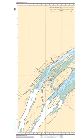
Navigate the gateway to Ontario’s Far North with Nautical Chart 5861. This specialized hydrographic map provides essential, high-detail coverage for the Moose River transit, spanning from Ship Sands Island at the mouth of James Bay to the vital transport hub of Moosonee.
Chart 5861 is a critical resource for navigating one of Canada’s most unique and challenging inland waterways. Because the Moose River is known for its shifting sandbars, significant tidal influences from James Bay, and varying water levels, this chart offers the most accurate bathymetric data and channel markings available. It features detailed shoreline topography, identifies hazardous shoals, and provides the exact positioning of seasonal navigational aids. Whether you are a commercial barge operator delivering essential supplies or a wilderness traveler heading to Tidewater Provincial Park, this chart provides the professional precision required for safe river pilotage.
Key Features:
Riverine Navigation Specialty: Comprehensive mapping of the main shipping channel from the James Bay estuary inland to Moosonee.
Hydrographic Precision: Features essential depth data and bottom characteristics for the shallow and sediment-heavy Moose River system.
Moosonee & Moose Factory Detail: Provides clear coastal landmarks and docking information for the region's primary settlements.
Tidal & Hazard Marking: Highlights areas prone to shifting depths and submerged obstructions unique to subarctic river environments.