QUESTIONS? CALL OR TEXT! 1 (877) 921-6277 or (403) 266-2241
WE SHIP EVERYWHERE!

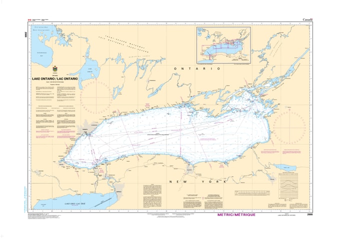
Command the full expanse of the smallest but most technically diverse Great Lake with the 2000 - Lake Ontario Nautical Chart. This professional-grade hydrographic reference is the "big picture" guide required for safe passage through the entire basin. As the primary entry point for vessels transiting the St. Lawrence Seaway, Chart 2000 provides the essential context for both international commercial traffic and long-distance recreational cruisers.
Produced to the rigorous standards of the Canadian Hydrographic Service (CHS), Chart 2000 delivers a comprehensive overview of the lake's hydrography:
International Coverage: Features detailed coastal and offshore data for both the Canadian and American shores, spanning from the Niagara River in the west to the head of the St. Lawrence in the east.
Master Transit Planning: The ideal chart for plotting cross-lake routes between major hubs such as Toronto, Rochester, Hamilton, Oshawa, and Kingston.
Major Approaches: Clear identification of the approaches to the Welland Canal, the Main Duck Island passage, and the technical entrance to the Thousand Islands.
Depths & Bathymetry: Showcases the dramatic underwater topography of the lake, including the deep central basins and the critical shoal areas of the northeastern corner.
Beyond its use on the bridge, this chart serves as a sophisticated piece of maritime history and art for those with a connection to the Golden Horseshoe or the North Country.
Official Technical Aesthetic: Showcases the intricate line work, sounding density, and universal maritime symbols that define professional hydrography.
High-Definition Print: Every lighthouse, buoy, and depth contour is rendered with sharp clarity, making it perfect for route planning, marine research, or professional display.
The Perfect Maritime Gift: An ideal memento for yacht club members, merchant mariners, and anyone who feels the pull of the "Sweetwater Seas."
| Feature | Details |
| Chart Number | 2000 |
| Location | Lake Ontario (International Waters) |
| Scale | 1:400,000 |
| Key Areas | Toronto, Kingston, Rochester, Hamilton, Welland Canal |
| Data Type | Hydrographic (General Depths, Navigational Aids, Shipping Lanes) |
| Publisher | Canadian Hydrographic Service (CHS) Standards |