QUESTIONS? CALL OR TEXT! 1 (877) 921-6277 or (403) 266-2241
WE SHIP EVERYWHERE!

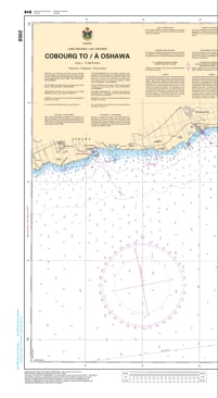
The 2058 – Cobourg to Oshawa Nautical Chart from the Canadian Hydrographic Service (CHS) provides accurate and authoritative navigational information for marine travel along the Lake Ontario shoreline between Cobourg and Oshawa. Produced using official hydrographic surveys, this chart delivers essential data required by commercial operators, recreational boaters, and fishing vessels for safe navigation.
CHS charts function as the “road maps” of Canada’s waterways, guiding mariners safely from port to port. With increasing commercial shipping, recreational boating, and coastal development, these charts are vital tools for safe and efficient marine navigation.
Specifically designed to meet marine navigation requirements, this chart provides detailed hydrographic and coastal information to support route planning, hazard awareness, and safe vessel operation.
Accurate Water Depths — Detailed bathymetric soundings and depth contours.
Seafloor Composition — Information on bottom characteristics for anchoring and navigation.
Coastal Topography — Shoreline configuration, elevations, and physical features.
Navigation Hazards — Identification of dangers, obstructions, and restricted areas.
Aids to Navigation — Buoys, lights, and navigational markers.
Official CHS Data — Produced to professional hydrographic standards.
Commercial shipping and transport operations
Recreational boating and sailing
Fishing vessels and charter operators
Marine navigation planning and safety
Maritime professionals and researchers
The Cobourg to Oshawa Nautical Chart 2058 provides reliable hydrographic information to help ensure safe navigation along Lake Ontario’s eastern shoreline.