QUESTIONS? CALL OR TEXT! 1 (877) 921-6277 or (403) 266-2241
WE SHIP EVERYWHERE!

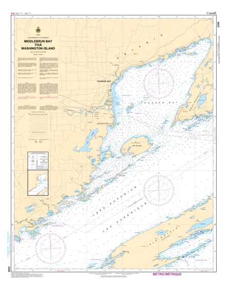
Navigate the deep, cold, and powerful waters of Lake Superior with the professional authority of the Canadian Hydrographic Service (CHS). Chart 2326 is the definitive navigational tool for mariners exploring the coast from the eastern approaches of Thunder Bay at Washington Island to the pristine reaches of Middlebrun Bay and Black Bay.
The North Shore is legendary for its sudden fog, dramatic underwater topography, and world-class scenery near Sleeping Giant Provincial Park. CHS Chart 2326 is engineered to provide:
Hydrographic Depth Precision: Vital for navigating the significant depths and sudden shoals near Porphyry Island and the entrance to Black Bay.
Seabed Characteristics: Identifies the nature of the bottom (rock, sand, or mud), which is crucial for secure anchoring in the exposed reaches of the North Shore.
Detailed Coastal Elevations: Shows the rugged configuration of the shoreline, assisting in radar navigation and visual pilotage near the historic Silver Islet.
Navigational Hazards & Aids: Clearly marks underwater pinnacles, "submerged cribs," and all official light stations and buoys maintained for safe passage.
As the development of northern ocean resources and eco-tourism expands, the role of official CHS charts is more vital than ever. Whether you are a commercial freighter captain, a professional angler targeting Lake Trout, or a recreational sailor exploring the Lake Superior National Marine Conservation Area, Chart 2326 provides the "ground-truth" data required for safe and successful transit.
| Feature | Details |
| Chart Number | 2326 |
| Region | Lake Superior, North Shore (Ontario) |
| Scale | Large-scale navigational detail |
| Publisher | Canadian Hydrographic Service (CHS) |
| Key Landmarks | Middlebrun Bay, Washington Island, Black Bay, Porphyry Island |
| Application | Commercial shipping, recreational cruising, and conservation monitoring |