QUESTIONS? CALL OR TEXT! 1 (877) 921-6277 or (403) 266-2241
WE SHIP EVERYWHERE!

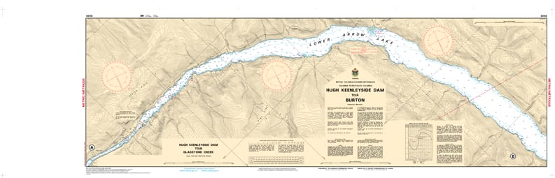

Navigate one of British Columbia’s most scenic and complex reservoir systems with the professional authority of the Canadian Hydrographic Service (CHS). Chart 3056 is a high-precision 2-sheet set providing the definitive data required to transit from the Hugh Keenleyside Dam (8km upstream of Castlegar) to the eastern shores of Burton.
The Arrow Lakes Reservoir is a man-made water body where levels can fluctuate significantly, creating hidden hazards. CHS Chart 3056 provides the "ground-truth" data required for:
Detailed 1:40,000 Scale: Offers the granular detail necessary for identifying safe leads through the Burton Narrows and across Burton Bar.
Lock Passage & Dam Approaches: Provides essential coastal configuration and depth soundings for the approaches to the Hugh Keenleyside Dam navigational lock, a critical junction for travel between the Columbia River and the Arrow Lakes.
Hazard & Obstruction Mapping: Explicitly marks submerged stumps, bars, and rocky shoals that may lie just below the surface during periods of low reservoir elevation.
Nature of the Bottom & Soundings: Includes accurate sea bottom characteristics and elevations, allowing mariners to find safe anchorage or plan for changing water levels that can shift up to 30 cm in a 24-hour period.
Whether you are a commercial tug operator, a serious angler, or a recreational boater exploring the Monashee Mountains, the role of Chart 3056 is more vital than ever. This official CHS "road map" is specifically designed to meet the requirements of marine navigation, ensuring you travel safely from port to port in the BC interior.
| Feature | Details |
| Chart Number | 3056 |
| Region | Pacific (BC Interior - Arrow Lakes) |
| Scale | 1:40,000 |
| Publisher | Canadian Hydrographic Service (CHS) |
| Format | 2-Sheet Set |
| Key Coverage | Hugh Keenleyside Dam, Lower Arrow Lake, Burton, Burton Narrows |