QUESTIONS? CALL OR TEXT! 1 (877) 921-6277 or (403) 266-2241
WE SHIP EVERYWHERE!

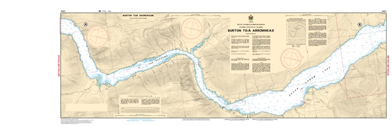
Navigate the scenic and technical waters of the Upper Arrow Lake with the professional authority of the Canadian Hydrographic Service (CHS). Chart 3057 is a high-precision 2-sheet set providing the definitive data required to transit from the northern reaches of Burton to the historic community of Arrowhead, covering the heart of the Arrow Lakes reservoir system.
Navigating the Arrow Lakes requires vigilance due to fluctuating reservoir levels that can obscure submerged hazards. CHS Chart 3057 provides the "ground-truth" data required for:
High-Resolution 1:40,000 Scale: Offers granular detail for the central and northern sections of the lake, including the deep-water approaches to Nakusp, Galena Bay, and Shelter Bay.
Safety Through the Narrows: Provides critical bathymetry and coastal configurations essential for navigating the changing shorelines and identifying safe leads during seasonal water level shifts.
Hazard & Obstruction Mapping: Explicitly marks submerged shoals, rocky outcrops, and timber-related hazards, ensuring safe passage for recreational boaters, commercial tugs, and ferry operators.
Inland Maritime Logistics: Essential for the safe operation of the Upper Arrow Lake Ferry system and local resource development, providing accurate data on seafloor nature and coastal elevations.
Whether you are a local resident, a commercial operator, or a visitor exploring the Monashee and Selkirk mountain ranges by water, the role of Chart 3057 is more vital than ever. This official CHS "road map" is specifically designed to meet the rigorous requirements of marine navigation, ensuring you travel safely from port to port in the BC interior.
| Feature | Details |
| Chart Number | 3057 |
| Region | Pacific (BC Interior - Arrow Lakes) |
| Scale | 1:40,000 |
| Publisher | Canadian Hydrographic Service (CHS) |
| Format | 2-Sheet Set |
| Key Coverage | Upper Arrow Lake, Burton, Nakusp, Galena Bay, Arrowhead |