QUESTIONS? CALL OR TEXT! 1 (877) 921-6277 or (403) 266-2241
WE SHIP EVERYWHERE!

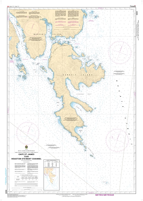
Navigate the powerful and rugged threshold of southern Haida Gwaii with the professional authority of the Canadian Hydrographic Service (CHS). Chart 3825 is the definitive 1:40,000 scale "road map" for mariners, providing the granular detail required for safe passage around Cape St. James—one of the most exposed and geologically significant points on the Pacific Coast—and into the vital waters of Houston Stewart Channel.
The transition from the open Pacific or Hecate Strait into the sheltered channels of Gwaii Haanas National Park Reserve requires extreme precision. CHS Chart 3825 provides the "ground-truth" data required for safe pilotage in this remote wilderness:
Cape St. James Detail: Features high-resolution mapping for the turbulent waters around the Cape and the Kerouard Islands, identifying submerged hazards in an area known for powerful currents and heavy sea states.
Houston Stewart Channel Coverage: Provides the bathymetric detail necessary to navigate the channel between Moresby Island and Kunghit Island, a primary route for eco-tourism, research, and fishing vessels.
Safe Haven Identification: Detailed mapping for the southern approaches to Louscoone Inlet and Rose Harbour, identifying secure anchorages and seafloor characteristics (rock, sand, or mud).
Navigational Hazards: Explicitly marks drying reefs, sea stacks, and underwater rocks that define the rugged southern coast of Haida Gwaii, ensuring situational awareness in varying visibility.
As the primary link for vessels entering the southern reaches of the Queen Charlotte Islands, the reliability of Chart 3825 is paramount. Specifically designed to meet the rigorous requirements of marine navigation, this official CHS chart delivers the accuracy and detail needed to navigate the wild heart of the North Pacific with total confidence.
| Feature | Details |
| Chart Number | 3825 |
| Region | Pacific Coast (Southern Haida Gwaii) |
| Scale | 1:40,000 |
| Dimensions | 36" x 49" (Standard Paper Size) |
| Publisher | Canadian Hydrographic Service (CHS) |
| Key Coverage | Cape St. James, Houston Stewart Channel, Kunghit Island, Louscoone Inlet |
| Compliance | Meets official carriage requirements for safe marine navigation |