QUESTIONS? CALL OR TEXT! 1 (877) 921-6277 or (403) 266-2241
WE SHIP EVERYWHERE!

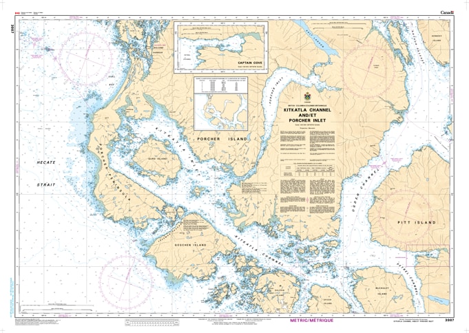
Navigate the culturally rich and geographically complex waters of the North Coast with the professional authority of the Canadian Hydrographic Service (CHS). Chart 3987 is the definitive 1:40,000 scale navigational guide for Kitkatla Channel and the deep, branching Porcher Inlet, providing the high-resolution data required for safe transit through these sheltered coastal reaches.
This region is characterized by narrow passages, significant tidal influences, and the historic community of Kitkatla. CHS Chart 3987 provides the "ground-truth" data required for safe pilotage:
Kitkatla Channel & Village Approaches: Features high-resolution mapping for the primary channel, providing essential data for vessels visiting the community of Kitkatla on Dolphin Island.
Porcher Inlet & The Salt Lakes: Detailed bathymetry for the long, winding Porcher Inlet, including the technical navigation required to reach the Salt Lakes, famous for their unique tidal rapids and reversing falls.
Goschen Island & Outer Passages: Provides the strategic data necessary to navigate the waters between Goschen Island and the western shore of Porcher Island, identifying safe leads in a reef-strewn environment.
Hazard & Anchorage Intelligence: Explicitly marks the numerous drying rocks, kelp beds, and small-craft anchorages (such as Billy Bay) that are vital for mariners exploring this rugged coastline.
As the primary navigational resource for local transport, commercial fishers, and wilderness cruisers, the reliability of Chart 3987 is paramount. Specifically designed to meet the rigorous requirements of marine navigation, this official CHS chart delivers the accuracy and detail needed to explore the Porcher Island region with total confidence.
| Feature | Details |
| Chart Number | 3987 |
| Region | Pacific Coast (North Coast BC / Porcher Island) |
| Scale | 1:40,000 |
| Dimensions | Approx. 36" x 45" (Standard Paper Size) |
| Publisher | Canadian Hydrographic Service (CHS) |
| Key Coverage | Kitkatla Channel, Porcher Inlet, Goschen Island, Salt Lakes |
| Compliance | Meets official carriage requirements for safe marine navigation |