QUESTIONS? CALL OR TEXT! 1 (877) 921-6277 or (403) 266-2241
WE SHIP EVERYWHERE!

 and National Parks. Perfect for legal, educational, and planning reference.")


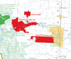
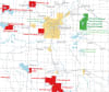
Gain a comprehensive and detailed view of Alberta's land use with our professional Alberta First Nations, Reserves & National Parks Wall Map. This essential reference tool is the only map you need to see the intersection of Indigenous territories and major protected areas across the province.
This map is invaluable for government agencies, educational institutions, environmental researchers, and anyone seeking a clearer understanding of Alberta's geography and land jurisdiction.
First Nation Reserves & Indigenous Lands: Clearly identifies all current First Nation Reserves (Indigenous Nations) and Settlements across Alberta.
Detailed Delineation: Reserves ≥ 2,000 acres are displayed as detailed polygons for clear jurisdictional understanding.
Smaller settlements (< 2,000 acres) are marked with precise point locations.
National & Protected Parks: Highlights the boundaries of all National Parks and other major Protected Areas within Alberta, including their proximity to First Nation territories.
Comprehensive Base Map: Includes vital geographical context, such as:
Major places and communities
Roads and railroads
Provincial and international boundaries
Built-up urban areas
Professional Quality: Available as a standard paper copy or an optional laminated wall map for superior protection and longevity in high-use settings.
Environmental Planning: Crucial for organizations involved in resource management, conservation, and land use planning near National Parks and First Nation Reserves.
Education & Public Display: An outstanding visual tool for teaching Alberta geography, Indigenous history, and environmental studies.
Legal & Government Reference: Essential for legal and government bodies requiring precise locations and boundaries for consultation, land claims, and policy development related to Alberta First Nations.
Secure your copy of this authoritative Alberta Wall Map—the definitive resource for visualizing the co-existence of First Nation Reserves and National Parks.