• QUESTIONS? CALL OR TEXT! 1 (877) 921-6277 or (403) 266-2241

  • WE SHIP EVERYWHERE!

Navigate to the undefined homepage

Prices are in Canadian funds

Home >
Alberta Municipal Districts & Counties Wall Map 1:1,000,000. The Municipal Districts version also shows all of the County and Municipal District boundaries. The maps shows primary and secondary highways, rivers, lakes, and other waterways, cities, towns,
Alberta Municipal Districts & Counties Wall Map 1:1,000,000. The Municipal Districts version also shows all of the County and Municipal District boundaries. The maps shows primary and secondary highways, rivers, lakes, and other waterways, cities, towns, - Image 1 of 0
Alberta Municipal Districts & Counties Wall Map 1:1,000,000. The Municipal Districts version also shows all of the County and Municipal District boundaries. The maps shows primary and secondary highways, rivers, lakes, and other waterways, cities, towns, - Image 2 of 0
Alberta Municipal Districts & Counties Wall Map 1:1,000,000. The Municipal Districts version also shows all of the County and Municipal District boundaries. The maps shows primary and secondary highways, rivers, lakes, and other waterways, cities, towns, - Image 3 of 0
Alberta Municipal Districts & Counties Wall Map 1:1,000,000. The Municipal Districts version also shows all of the County and Municipal District boundaries. The maps shows primary and secondary highways, rivers, lakes, and other waterways, cities, towns, - Image 4 of 0

Alberta Municipal Districts & Counties Wall Map 1:1,000,000

Alberta Sustainable Resource Development
$
Choose your options:
Style(optional):
Product Code: 30168

Alberta Municipal Districts & Counties Wall Map: DLS Grid & Administrative Boundaries

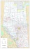
Navigate the administrative landscape of Alberta with our definitive Alberta Municipal Districts & Counties Wall Map. This essential resource is specifically designed to clearly delineate all County and Municipal District boundaries across the province.

This large-format map provides an indispensable visual reference for local government, real estate, land development, and any business operating in or servicing rural Alberta. The clear boundaries of the Municipal Districts (MDs) and Counties are vital for jurisdiction tracking, service planning, and regulatory compliance under the Municipal Government Act.

Designed at a precise 1:1,000,000 scale, this Alberta administrative map is the ultimate resource for visualizing Alberta's regional governance.

Key Features for Planning, Real Estate & Logistics

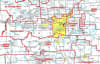
  • County & Municipal District Boundaries: Clearly marked and color-coded boundaries for all Alberta Municipal Districts and Counties, making this the authoritative MD boundary map.

  • Dominion Land Survey (DLS) Grid:Essential for real estate and land surveying, the map includes the complete DLS system: townships, sections, and meridians.

  • Complete Transportation Network: A reliable Alberta road map featuring primary and secondary highways (paved and unpaved), providing crucial context for logistics and travel.

  • Cadastral Planning: Includes precise latitude and longitude grids, aiding in accurate parcel identification and GIS system cross-referencing.

  • Geographic & Infrastructure Detail: Locate all major cities, towns, villages, airports, rivers, lakes, and other waterways.

  • Political Context: Clearly displays major political boundaries, providing a comprehensive base layer for regional planning.

Ideal Uses for the Alberta Municipal & County Map

  • Real Estate & Land Development: Use the detailed DLS grid to pinpoint land parcels and understand jurisdictional requirements across different Municipal Districts.

  • Local Government & Planning: Essential for government officials, urban planners, and consultants managing services, resources, and infrastructure projects across County lines.

  • Business Logistics: An invaluable business map of Alberta for service providers, utilities, and transport companies needing clear administrative and physical boundaries for route and service planning.

  • Educational Tool: A fantastic educational wall map for political science, geography, and public administration students.

This highly accurate and detailed Alberta Municipal Districts & Counties Wall Map is the critical planning tool you need for success across Alberta's diverse regions.

Purchase your Alberta Municipal Districts Map today and gain clear insight into the province's local jurisdictions!

Size: 32 Inches by 52 Inches
Scale: 1:1,000,000
Year: updated annually
Empty Cart