QUESTIONS? CALL OR TEXT! 1 (877) 921-6277 or (403) 266-2241
WE SHIP EVERYWHERE!


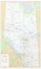
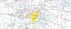


Scale: 1:750,000 (1 cm = 7.5 km)
Dimensions: 42 inches x 69 inches
Roads & Transportation:
Primary & Secondary Highways (paved and unpaved)
Railroads
Airports
Cities & Settlements:
Cities, Towns, and Villages
First Nations and Metis Settlements
Parks & Reserves:
Provincial, National, and Wildland Parks
Forest Reserves
Geographical Features:
Lakes & Rivers
Meridians, Townships, and Sections
Boundaries & Grids:
Latitude and Longitude grids
Military Bases
This comprehensive Alberta wall map is perfect for a variety of uses. Businesses can use it for logistics and territory planning, while educators can use it as a learning tool to teach students about Alberta's geography. It's also an invaluable resource for outdoor enthusiasts, helping to identify wildland areas, provincial parks, and forest reserves. The detailed depiction of townships and sections makes it particularly useful for land-use planning and real estate professionals.