• QUESTIONS? CALL OR TEXT! 1 (877) 921-6277 or (403) 266-2241

  • WE SHIP EVERYWHERE!

Navigate to the undefined homepage

Prices are in Canadian funds

Home >
The definitive Atlantic Provinces First Nations Wall Map. Shows all Indigenous Reserves, Settlements, Parks, and Communities in NB, NS, PEI, and NL. Essential reference.
The definitive Atlantic Provinces First Nations Wall Map. Shows all Indigenous Reserves, Settlements, Parks, and Communities in NB, NS, PEI, and NL. Essential reference. - Image 1 of 0
The definitive Atlantic Provinces First Nations Wall Map. Shows all Indigenous Reserves, Settlements, Parks, and Communities in NB, NS, PEI, and NL. Essential reference. - Image 2 of 0
The definitive Atlantic Provinces First Nations Wall Map. Shows all Indigenous Reserves, Settlements, Parks, and Communities in NB, NS, PEI, and NL. Essential reference. - Image 3 of 0

Atlantic Canada First Nations & Reserves Wall Map | Mi'kmaq, Maliseet

Map Town
$
Choose your options:
Style(optional):
Product Code: 99501

Atlantic Provinces First Nations & Reserves Wall Map

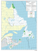
Explore the rich history and modern geography of Indigenous Peoples on the East Coast of Canada with the definitive Atlantic Provinces First Nations Wall Map. This comprehensive and highly detailed map is an essential visual guide to First Nation Reserves and communities across the four provinces of Newfoundland & Labrador, New Brunswick, Prince Edward Island (PEI), and Nova Scotia.

Ideal for educational institutions, government offices, tourism operators, and organizations involved in Indigenous relations, this map clearly delineates the lands of the Mi'kmaq, Maliseet, and other Indigenous Nations across the region.

Key Features for Regional & Indigenous Context

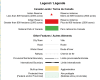
  • First Nation Reserves & Settlements: Accurately displays all Indian Reserves and Indigenous Settlements across Atlantic Canada.

    • Reserves 2,000 acres are shown as detailed polygons for clear jurisdictional visualization.

    • Smaller settlements (< 2,000 acres) are marked with precise point locations.

  • Comprehensive Coverage: Includes all four provinces: Newfoundland & Labrador, New Brunswick, PEI, and Nova Scotia.

  • Base Map Detail: Provides full geographical context, including all major places, roads, railroads, provincial boundaries, and built-up areas.

  • Protected & Heritage Areas: Clearly depicts National and Provincial Parks, Protected Areas, and significant features like heritage canals.

  • Durability & Options: Available as a standard paper copy or as a laminated wall map for superior longevity and durability, making it perfect for high-use public or office spaces.

Ideal Uses for the Atlantic First Nations Map

  • Educational Resource: An unparalleled teaching tool for subjects like Canadian history, Indigenous studies, and geography in the Maritimes.

  • Regional Planning: Essential for governments and businesses requiring accurate locations of First Nation communities for consultation, development, and infrastructure planning in Atlantic Canada.

  • Cultural Reference: A vital resource for libraries and cultural centres documenting the geography and communities of Mi'kma'ki and the Wolastoqey Nation.

Purchase the definitive geographical resource for First Nation lands in the Atlantic Provinces. Order your map today.

Size: 41 Inches by 31 Inches
Scale: 1:20,000,000
Year: 2023
Empty Cart