QUESTIONS? CALL OR TEXT! 1 (877) 921-6277 or (403) 266-2241
WE SHIP EVERYWHERE!


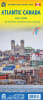
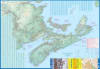
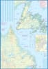
Embark on an unforgettable journey through Eastern Canada with the most comprehensive single-sheet map available. Our Atlantic Canada Travel Map is your ideal companion for planning a grand circle trip or extended exploration, expertly combining four fascinating provinces onto one durable sheet.
Meticulously covers the picturesque landscapes and rich history of the Maritime provinces:
Nova Scotia, New Brunswick, and Prince Edward Island (PEI).
Includes Quebec's captivating Magdalen Islands.
Highlights the Top 10 Attractions to guide your exploration through the scenic drives and coastal routes.
Devoted to the rugged charm of Newfoundland and Labrador. The smaller island portion is detailed at 1:150,000, while the vast mainland Labrador is at 1:1,700,000.
Historic St. John's: Features a crucial inset map of one of North America's oldest and most vibrant cities.
Unique Inclusions: Covers the northernmost tip of Quebec/Labrador belonging to Nunavut, and the French overseas possession of St. Pierre et Miquelon.
Lists 9 Top Attractions across Newfoundland and Labrador.
Navigate the wild beauty of Atlantic Canada with confidence. This map is not only designed for clarity and detail but is printed on revolutionary, durable, waterproof, decomposable stone paper. It offers exceptional resilience against the elements while remaining an environmentally friendly choice.
Perfect for extended travel and serious exploration. Secure the only map you need for your entire Atlantic Canada adventure!