QUESTIONS? CALL OR TEXT! 1 (877) 921-6277 or (403) 266-2241
WE SHIP EVERYWHERE!

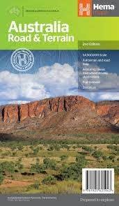
Visualize the vastness of the Australian continent with the Hema Road & Terrain Map. This isn't just a navigation tool; it’s a strategic planning asset for anyone dreaming of the "Big Lap" or venturing into the rugged Red Centre.
Featuring high-accuracy contour and hill shading, this map allows you to see the elevation of the Great Dividing Range and the undulations of the Simpson Desert before you even put the car in gear.
Comprehensive Road Network: From the sealed highways of the East Coast to the unsealed corrugated tracks of the Kimberley and the Top End.
Precision Distance Data: Every major route includes clear distance markings in kilometers, essential for calculating fuel stops and daylight driving hours in remote areas.
Climate & Terrain Visuals: Unique color-coding reflects Australia’s diverse climate zones—helping you understand when you're moving from temperate coastal plains into arid desert heartlands.
Flip the map over to discover a curated travel guide. The reverse side features full-color photography and detailed descriptions of nineteen iconic Australian areas, including:
The Kimberley & Top End: Expert insights into the monsoon tropics.
The Red Centre: Navigating the spiritual heart of the outback.
The Nullarbor & Great Australian Bight: Planning the world's longest straight road.
The High Country: Discovering the alpine ridges of Victoria and NSW.
Scale: 1:4,500,000 (Ideal for national route planning).
Topography: Detailed digital terrain modeling (DTM) with relief shading.
National Parks & Indigenous Lands: Clearly marked boundaries for respectful and legal travel.
Outback Fuel Stops: Vital markings for roadhouses and remote fuel points.
"In the Australian Outback, 'No Service' is a common reality. While your GPS tells you where you are, the Hema Terrain Map tells you what’s coming—the heat of a climate zone shift, the steepness of a mountain pass, and the sheer scale of the desert ahead. It is the only way to effectively plan fuel and water stops across the world's sixth-largest country."