QUESTIONS? CALL OR TEXT! 1 (877) 921-6277 or (403) 266-2241
WE SHIP EVERYWHERE!


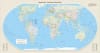
The Equal Earth World Wall Map (Florence-Centered) provides a fresh, sophisticated perspective on global geography by centering the world on approximately $11.25^\circ E$. This large-format map allows viewers to see the relationship between Europe, Africa, and the Americas in a continuous, uninterrupted layout that is both functional and visually stunning.
Unlike the common Mercator projection, which distorts the size of countries near the poles, the Equal Earth projection shows continents and countries at their true relative size to one another. This ensures that Africa, South America, and Australia are represented fairly and accurately according to their actual landmass.
Unmatched Scale: At 55 x 30 inches, this map offers exceptional clarity for reading city names, capitals, and international borders.
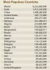
Most Populous Countries Table: Includes up-to-date data for the world's most populous nations, listing the global population at approximately 8,232,000,000 people.
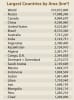
Largest Countries by Area Table: A quick-reference guide for the world’s largest nations by landmass, totaling 510,072,000\ km sq for the entire planet.
Caribbean Island Reference: Features a specialized index for small Caribbean island capitals, such as The Valley (Anguilla) and Saint John’s (Antigua and Barbuda).
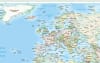
Visual Topography: Soft shaded relief highlights the Earth's mountain ranges while maintaining clear political legibility.
| Feature | Specification |
| Title | Equal Earth - Countries of the World |
| Projection | Equal Earth (Equal-Area Pseudocylindrical) |
| Dimensions | 55" Wide x 30" High |
| Centering | Florence, Italy (approx. 11.25 degrees East) |
| Included Data | Top Populous Countries, Top Areas, Caribbean Capitals |
| Color Palette | Modern pastel tones with light-shaded terrain relief |