QUESTIONS? CALL OR TEXT! 1 (877) 921-6277 or (403) 266-2241
WE SHIP EVERYWHERE!

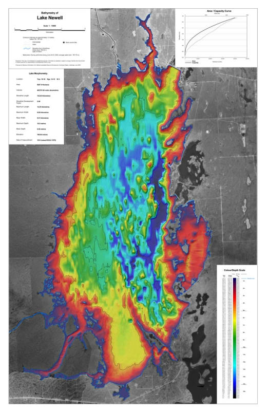
Pinpoint prime structure and target trophy walleye and northern pike with the official Lake Newell Bathymetric Chart. Located in southern Alberta near Brooks, Lake Newell is one of the province's largest and most productive man-made reservoirs. This high-precision depth chart translates underwater topography into clear visual data, giving anglers, fisheries researchers, and recreational boaters an immediate tactical advantage on the water.
Just as a topographic map reveals mountain ridges and valleys, this bathymetric map illustrates underwater depth contours, drop-offs, submerged points, shoals, and basin flats. By revealing critical underwater structure where sportfish hold and feed throughout changing seasons, this chart takes the guesswork out of locating productive fishing spots across Lake Newell's expansive surface area.
Detailed Depth Contours: Features precise underwater contour lines highlighting sharp drop-offs, deep basins, shallow flats, submerged weedlines, and underwater points.
Angler & Fisheries Optimization: Essential tool for trolling, vertical jigging, and ice fishing—helping anglers quickly identify walleye reefs and giant pike holding zones.
Navigation & Safety Features: Clearly marks boat launch facilities, marinas, island hazards, shallow shoals, and shore access points across Lake Newell and Kinbrook Island Provincial Park.
Geospatial & Spatial Precision: Built with accurate scale and geographic orientation for seamless cross-referencing with marine GPS chartplotters and fishfinders.
Durable Field Printing: Printed on heavy-duty, water-resistant paper designed to endure wet hands, boat sprays, and rigorous boat deck use.
Whether navigating open water during summer walleye tournaments or setting up ice huts over mid-lake structure in winter, this bathymetric depth map is an essential physical reference for fishing Lake Newell.