QUESTIONS? CALL OR TEXT! 1 (877) 921-6277 or (403) 266-2241
WE SHIP EVERYWHERE!


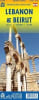
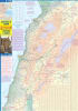
Plan your journey, prepare your itinerary, and travel independently through Lebanon with this highly detailed, easy-to-use road map. As a comprehensive, one-sided map of the entire country, it is the perfect tool for exploring the rich history and diverse natural beauty of the Levant.
The map legend is packed with information for every type of traveler, from history buffs to nature enthusiasts:
World Heritage Sites: Clearly locate all major UNESCO-listed sites, including the Roman ruins of Baalbek, the ancient Phoenician cities of Byblos and Tyre, and the sacred Kadisha Valley (Valley of the Saints).
Natural Wonders: Find major geographical features and attractions like the Cedar Forests (Cedars of God), ski areas in the Mount Lebanon range, the fertile Bekaa Valley, beaches, springs, and caves (Jeita Grotto).
Historical & Cultural: Locates museums, ruins, castles (Crusader), religious buildings (Mosques, Monasteries), and archaeological sites.
This map is specifically designed for the independent traveler and driver:
Road Network:Roads by classification are clearly marked to help visitors find the best routes between cities (Tripoli, Beirut, Sidon).
Essential Services: Features crucial logistical points, including Gas stations, Hospitals, Embassies, Hotels, and Airports.
Terrain Detail: Includes Elevation ranges to help visualize the dramatic landscape, rising steeply from the coast.
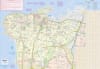
The map includes a highly functional inset map of Beirut, the vibrant capital, to help you navigate its modern and ancient sections, pinpointing:
Places of Interest
Accommodation
Parks and Theaters
Plan your journey from the Roman temples of Baalbek to the cosmopolitan streets of Beirut with this essential Lebanon travel map.