QUESTIONS? CALL OR TEXT! 1 (877) 921-6277 or (403) 266-2241
WE SHIP EVERYWHERE!

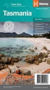
Discover why Tasmania is Australia’s premier road trip destination. The Hema Tasmania State Map is a meticulously detailed touring tool, perfect for navigating everything from the bustling markets of Hobart to the rugged temperate rainforests of the Tarkine.
At a touring-friendly 1:500,000 scale, this double-sided map provides the high-fidelity detail needed to manage Tasmania's unique driving conditions—where 100km can feel like 300km due to the dramatic, winding terrain.
Tasmania's wilderness is beautiful but unforgiving. This map is engineered for safety and discovery:
The Driver’s Essential: Clearly marked highways, secondary roads, and national routes with detailed road distances in kilometers.
Off-Grid Logistics: Essential markings for outback fuel stops, 24-hour service stations, and roadside rest areas.
Stay Your Way: Fully indexed locations for camping areas, caravan parks, and luxury eco-lodges.
Topographic Depth: Features relief shading to help you visualize the elevation of the Central Highlands and the Western Wilds.
Plan your visit to the island’s most celebrated sites, all clearly marked for easy access:
Cradle Mountain-Lake St Clair: Navigate the gateway to the Overland Track and find the best views of Dove Lake.
Freycinet National Park: Master the route to Coles Bay for the iconic hike to Wineglass Bay.
Port Arthur Historic Site: Explore the UNESCO World Heritage convict site on the Tasman Peninsula.
MONA (Hobart): Easily find your way to the world-famous Museum of Old and New Art on the banks of the Derwent.
Bruny Island: Includes ferry access points and road links to the lighthouse and the gourmet "Neck" lookout.
"In Tasmania, distances are deceptive. A 'short' drive on the map often involves dozens of hairpin turns and steep climbs. This Hema map includes a distance grid that is vital for planning your day—ensuring you reach your campsite or the Spirit of Tasmania ferry in Devonport before the sun goes down and the wildlife comes out."