QUESTIONS? CALL OR TEXT! 1 (877) 921-6277 or (403) 266-2241
WE SHIP EVERYWHERE!

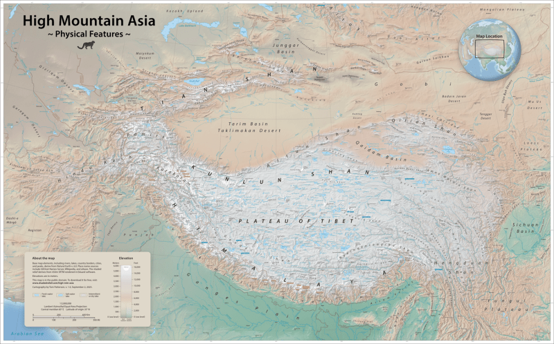


Explore the most formidable terrain on Earth with the High Mountains of Asia Wall Map. Covering the vast "Third Pole" region, this map provides an unparalleled look at the interconnected systems of the Himalayas, Karakoram, Hindu Kush, Pamirs, and the Tian Shan. It is an essential resource for geographers, mountaineers, and anyone fascinated by the tectonic majesty of Central Asia.
Designed by elite cartographers to capture the complexity of high-altitude geography, this map offers:
Exaggerated Shaded Relief: 3D-rendered digital modeling brings the verticality of the world’s fourteen 8,000-meter peaks—including Everest, K2, and Annapurna—to life with stunning clarity.
The Third Pole Perspective: Beyond the peaks, it highlights the immense Tibetan Plateau, the headwaters of Asia’s great rivers (the Indus, Ganges, and Yangtze), and the critical glacial systems that provide water to billions.
Cultural & Natural Context: Features detailed labels for mountain passes, remote high-altitude lakes, and populated valleys, alongside the international borders of Nepal, Bhutan, Tibet, India, Pakistan, and China.
Environmental Tints: Uses specialized hypsometric tints to distinguish between arid rain-shadow basins, alpine tundra, and the permanent snowlines of the "eternal snows."
Whether displayed in a research library, a climbing gym, or a home study, this map is built for impact. Printed in high-resolution 350 DPI, every ridge line and deep-cut gorge is rendered with absolute precision. This is the ultimate "road map" for understanding the geological and environmental heart of the Asian continent.
| Feature | Details |
| Coverage | Central Asia (Himalayas to the Tian Shan) |
| Projection | Albers Equal-Area Conic (Optimized for mountain ranges) |
| Key Features | Shaded Relief, Glacial Extents, River Headwaters, Peaks over 8000m |
| Dimensions | Custom Wall Size (Optimized for large-scale display) |
| Resolution | 350 DPI (RGB High-Resolution) |
| Language | English (Official Geographic Transliterations) |