QUESTIONS? CALL OR TEXT! 1 (877) 921-6277 or (403) 266-2241
WE SHIP EVERYWHERE!

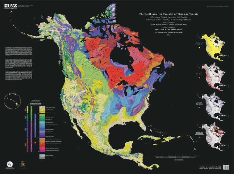


Explore the deep history of our continent with the North America Tapestry of Time and Terrain. This expansive 39" x 52" wall map is a collaborative triumph between the U.S. Geological Survey (USGS) and the Geological Survey of Canada. By combining detailed geologic age data with shaded-relief imagery, this map creates a stunning visual "tapestry" that reveals how ancient tectonic events have shaped the modern landscape.
Unlike standard geologic maps, this "tapestry" uses a sophisticated color-coding system to represent the Geologic Time Scale:
The Tapestry Effect: Shaded relief provides a 3D perspective of mountains, valleys, and plains, while superimposed colors indicate the age of the underlying rock.
Rock Classification: Four specialized inset maps break down the continent by rock type: Sedimentary (yellow), Volcanic (red), Plutonic (blue), and Metamorphic (brown).
Temporal Depth: From the ancient Precambrian shields (purple/pink) to the recent Quaternary deposits (yellow), the map traces over 4 billion years of North American history.
Large-Format Detail: At 39 by 52 inches, this map offers unparalleled legibility for study or display.
Academic Precision: Compiled by renowned geologists Kate E. Barton, David G. Howell, José F. Vigil, John C. Reed, Jr., and John O. Wheeler.
Multilingual Reference: Features titles and legends in English, Spanish (Cobertura de Tiempo y Terrenos), and French (L’Amérique du Nord: un collage de terrains d’âges différents).
| Feature | Details |
| Title | The North America Tapestry of Time and Terrain |
| Publisher | U.S. Geological Survey (USGS) in collab with Geological Survey of Canada |
| Dimensions | 39 x 52 inches |
| Primary Imagery | Geologic age combined with 3D shaded relief |
| Rock Type Insets | Sedimentary, Volcanic, Plutonic, Metamorphic |
| Time Scale | 4 billion years (Precambrian to Quaternary) |