QUESTIONS? CALL OR TEXT! 1 (877) 921-6277 or (403) 266-2241
WE SHIP EVERYWHERE!


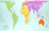
Challenge traditional geographical biases with the Peters World Map. Designed as a "fairer" alternative to the Mercator projection, this equal-area map correctly displays countries according to their actual surface area. Whether for a classroom, home office, or personal study, this map ensures that continents like Africa and South America are no longer physically diminished compared to Europe and North America.
Proportional Accuracy: All countries and continents are shown in true proportion to one another, providing a helpful corrective to traditional map distortions.
Continental Color-Coding: An updated, multi-colored scheme groups countries by continent within the same color family, making delineation and identification effortless.
Major Urban Data: Includes precise labels for cities with populations over 100,000, alongside national capitals and major bodies of water.
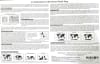
Comparison Guide: The reverse side serves as a comprehensive educational resource, featuring an in-depth explanation of various map projections to help users understand how different cartographic choices shape our worldview.
Perfect Sized Format: The 11" x 17" dimensions make it an ideal desk reference or wall display piece.
Laminated Protection: Features high-quality lamination for a moisture-resistant, tear-proof finish that withstands the rigors of frequent classroom use.
Globally Trusted: Adopted by UNESCO, the UN, and major public school districts for its commitment to social justice and global awareness.
| Feature | Details |
| Projection Type | Gall-Peters (Equal Area) |
| Dimensions | 11.02" x 16.93" (approx. 11x17) |
| Map Features | Continental color-coding, major cities (>100k), capitals |
| Reverse Content | Comparative map projection explanations and thumbnails |
| Durability | Double-sided lamination |