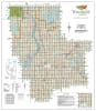
Westlock County Landowner Map - County 92. County and Municipal District (MD) maps show surface land ownership with each 1/4 section labeled with the owners name. Also shown by color are these land types - Crown (government), Freehold (private) and Crown Leased lands. The maps show parks, cities, towns, villages, lakes, rivers and very current for road information, including Township and Range roads. Scale 1:100,000.

 maps show surface land ownership with each 1/4 section labeled with the owners name. Also shown by color are these land types - Crown (government), Freehold (private) and Crown")