QUESTIONS? CALL OR TEXT! 1 (877) 921-6277 or (403) 266-2241
WE SHIP EVERYWHERE!

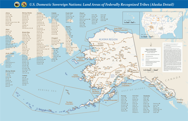
Examine sovereign Alaska Native land tenure, regional corporation boundaries, and village jurisdictions with the official U.S. Domestic Sovereign Nations: Land Areas of Federally Recognized Tribes (Alaska Detail) Wall Map, produced by the Bureau of Indian Affairs (BIA) Branch of Geospatial Support. This detailed cartographic reference offers a comprehensive spatial overview of sovereign Indigenous entities, Alaska Native Regional Corporations, and federal administrative boundaries across Alaska.
Designed for legal professionals, researchers, educators, land managers, and public policy analysts, this specialized thematic map illustrates the spatial distribution and administrative framework of federally recognized Alaska Native villages, tribal entities, and regional corporations. It clearly delineates boundaries for major Alaska Native Regional Corporations—including Arctic Slope, N.A.N.A., Doyon, Bering Straits, Calista, Cook Inlet, Chugach, Bristol Bay, Koniag, Ahtna, and Sealaska—alongside BIA regional office divisions and Annette Islands Reserve trust lands.
Authoritative BIA Cartography: Official Bureau of Indian Affairs spatial data depicting land areas, tribal statistical areas, and village locations of federally recognized entities across Alaska.
Alaska Native Regional Corporations: Clearly maps regional corporation boundaries established under ANCSA, providing key context for land ownership, resource management, and regional governance.
Index of Alaska Native Villages & Entities: Includes an organized margin directory indexing hundreds of recognized village entities across regional divisions (e.g., Ahtna, Aleut, Arctic Slope, Bering Straits, Bristol Bay, Calista, Chugach, Cook Inlet, Doyon, Koniag, N.A.N.A., Sealaska) cross-referenced to numbered map locations.
BIA Administrative & Regional Infrastructure: Pinpoints BIA Regional Offices and agency locations that oversee trust responsibilities and intergovernmental relations.
National Context Inset: Features a reference map insert displaying the broader lower-48 United States tribal land context.
Essential Policy & Research Tool: An indispensable spatial reference for legal offices, university departments, government agencies, corporate land departments, and non-profit organizations operating in Alaska.
Whether conducting legal research, coordinating intergovernmental policy, or studying Alaska Native land rights, the Alaska Detail Federally Recognized Tribes Wall Map provides essential cartographic accuracy and administrative clarity.