QUESTIONS? CALL OR TEXT! 1 (877) 921-6277 or (403) 266-2241
WE SHIP EVERYWHERE!


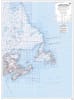
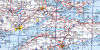
Navigate the diverse coastal and inland landscapes of Eastern Canada with the Atlantic Provinces Base Map, rendered at a comprehensive 1:2,000,000 scale.
Designed for professional, industrial, and educational use, this map integrates the National Topographic System (NTS) grid, making it an essential tool for resource management, maritime planning, and regional logistics. The map offers high-clarity visualization of the region's complex geography, featuring primary and secondary highways, major airports, and intricate hydrography including rivers, lakes, and Atlantic waterways.
Key Features include:
Comprehensive Infrastructure: Clearly identifies major cities, towns, villages, and regional transportation hubs across all four Atlantic provinces.
Political & Geographic Markers: Detailed delineation of provincial and international boundaries, supported by a precise latitude and longitude grid for global positioning.
NTS Grid Integration: Includes the full National Topographic System index, allowing for seamless cross-referencing with detailed 1:50,000 and 1:250,000 topographic sheets.
Unified Regional View: A rare single-sheet overview that combines the Maritimes with Newfoundland and Labrador, as well as adjacent areas of Quebec.
Whether utilized for environmental assessment, administrative planning, or as a high-quality cartographic display, this Atlantic Provinces Base Map offers an unmatched level of detail for Canada's eastern gateway.