QUESTIONS? CALL OR TEXT! 1 (877) 921-6277 or (403) 266-2241
WE SHIP EVERYWHERE!

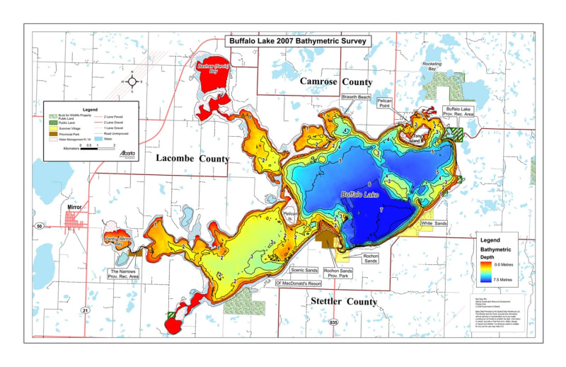
Target key underwater structure and safely navigate Central Alberta’s largest recreational lake with the official Buffalo Lake Bathymetric Survey Chart. Spanning Lacombe County, Camrose County, and Stettler County, Buffalo Lake is a premier destination for northern pike, walleye, and burbot anglers, as well as boaters and cottage owners. This high-precision color depth map translates complex underwater bathymetry into clear visual data, giving anglers and outdoor enthusiasts an immediate tactical advantage on the water.
Much like a terrestrial topographic map reveals land contours, this bathymetric chart illustrates underwater depth gradients, shallow sandbars, drop-offs, island humps, and deep basin zones. Featuring vivid color gradients ranging from red in shallow bays (0.0 Metres) down to deep blue basin trenches (7.5 Metres), this map takes the guesswork out of locating productive fishing spots across Parlby Bay, Main Bay, and Eastern Basins.
High-Definition Color Gradient Contours: Features a full depth spectrum from shallow 0.0m red zones to deep 7.5m blue basin pockets, making it easy to identify sharp drop-offs and underwater points.
Complete Shoreline & Resort Infrastructure: Clearly marks local summer villages and beach communities, including Rochon Sands, White Sands, Scenic Sands, Ol' MacDonald's Resort, Braseth Beach, Pelican Point, and Bashaw (Jarvis) Bay.
Parks & Protected Land Classifications: Pinpoints Rochon Sands Provincial Park, Buffalo Lake Provincial Recreation Area, The Narrows Provincial Recreation Area, Public Land corridors, and Buck for Wildlife Property.
Island & Navigation Hazards: Highlights prominent islands such as Pelican Island, Tony's Island, and shallow reefs across Rockeling Bay and Parlby (Mirror) Bay.
Comprehensive Road Network: Displays access via Highway 21, Highway 50, and Highway 835, detailing 2-lane paved, 2-lane gravel, 1-lane gravel, and unimproved access roads.
Whether trolling deep basins during summer, launching from Rochon Sands, or setting up ice shelters over mid-lake drop-offs, this bathymetric depth map is an essential physical reference for exploring Buffalo Lake.