QUESTIONS? CALL OR TEXT! 1 (877) 921-6277 or (403) 266-2241
WE SHIP EVERYWHERE!


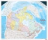
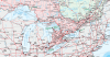
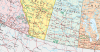
The Canada Political Wall Map by Natural Resources Canada (NRCan) is an authoritative, highly detailed reference map from the prestigious Atlas of Canada Reference Map Series. Published at a 1:6,000,000 scale, this official masterwork delivers unmatched cartographic precision, capturing Canada's vast physical and geopolitical landscape from the Atlantic to the Pacific and north to the Arctic Ocean.
Boundaries & Economic Zones: Clearly depicts all international borders, provincial/territorial boundaries, and Canada's 200-nautical-mile offshore Exclusive Economic Zone (EEZ).
National Parks & Protected Reserves: Includes comprehensive coverage of national parks and reserves across every province and territory—including recently established sites like Nááts'ihch'oh National Park Reserve (NWT) and Sable Island National Park Reserve (Nova Scotia).
Physiographic & Hydrographic Detail: Highlights major landforms, mountain chains, river basins, and lake systems, providing critical geographic reference points across remote northern and wilderness regions.
National Infrastructure: Features a clearly rendered transportation network showing major highways, primary freight rail lines, and coastal ferry routes, with the Trans-Canada Highway highlighted across the country.
3D Perspective Projection: Cartographically engineered using a vertical near-side perspective projection, creating a unique three-dimensional visual curvature that authentically captures Canada's vast continental scale.
Designed for government offices, corporate boardrooms, educational institutions, dispatch hubs, and home libraries, this official NRCan wall map serves as the gold standard in Canadian reference cartography.