QUESTIONS? CALL OR TEXT! 1 (877) 921-6277 or (403) 266-2241
WE SHIP EVERYWHERE!

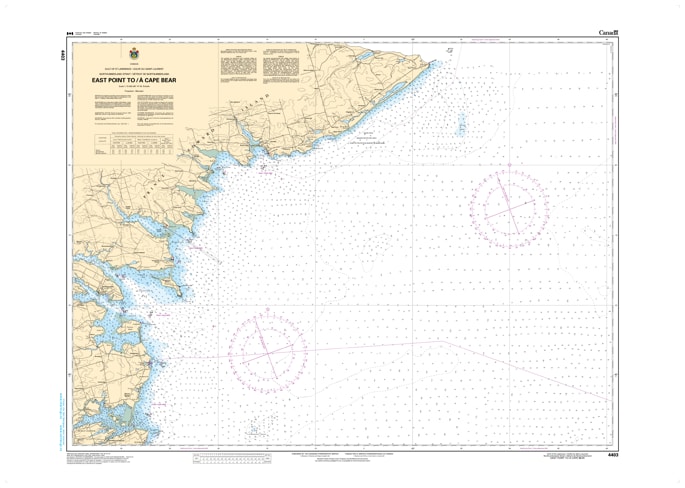
Navigate the eastern tip and southeastern coast of Prince Edward Island with the Canadian Hydrographic Service (CHS) Nautical Chart 4403. This official marine chart provides comprehensive coverage of the Northumberland Strait and Gulf of St. Lawrence waters from East Point down to Cape Bear. Mapped at a detailed 1:75,000 scale, it is the primary navigational resource for mariners transiting the scenic but challenging "Red Point" coast.
As an official CHS publication, Chart 4403 is essential for safely rounding the eastern extremity of the island. It features high-density bathymetric soundings (in metres) and detailed seafloor characteristics, which are vital for avoiding the treacherous shoals off East Point—where the tides of the Northumberland Strait meet the Gulf of St. Lawrence. The chart provides accurate positioning for iconic navigation aids, including the East Point Lighthouse and the Cape Bear Lighthouse, as well as the approaches to Souris Harbour and the bustling ferry terminals. Updated to the latest Notice to Mariners (NTM), this chart is indispensable for commercial fishing fleets, shipping vessels, and recreational boaters exploring the white sand beaches and red sandstone cliffs of PEI’s eastern shore.
Chart Number: 4403
Scale: 1:75,000
Region: Gulf of St. Lawrence / Northumberland Strait (Prince Edward Island)
Coverage: East Point, Red Point, Souris Harbour, Colville Bay, Rollo Bay, Boughton Bay, and Cape Bear.
Dimensions: Approximately 33" x 47" (Standard large format).
Format: Printed on heavy-duty kraft paper; meets official carriage requirements for vessels in Canadian waters.
East Point Shoal Data: Crucial detail for navigating the turbulent waters and shifting sandbars where the island's currents converge.
Souris Harbour Approaches: Detailed mapping of the breakwaters and depths for the major port of Souris, the gateway to the Magdalen Islands.
Aids to Navigation: Precise locations and light characteristics for lighthouses at East Point, Souris (Cape Fortune), and Cape Bear.
Safety Information: Clearly identifies shipwrecks, fishing zones, and submarine cables in the Northumberland Strait.