QUESTIONS? CALL OR TEXT! 1 (877) 921-6277 or (403) 266-2241
WE SHIP EVERYWHERE!

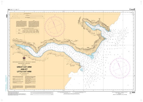
Explore the dramatic and deeply indented fjords of the Great Northern Peninsula with the precision of CHS Nautical Chart 4504. Providing high-resolution, large-scale coverage of Great Cat Arm and Little Cat Arm, this chart is an essential resource for mariners navigating the western shores of White Bay, Newfoundland. Known for their steep, mountainous shorelines and profound depths, these arms offer some of the most striking coastal scenery and sheltered anchorages in the province.
Chart 4504 features detailed hydrographic mapping of these remote inlets, which are carved into the rugged Long Range Mountains. It provides critical data for the narrow entrances and deep-water basins of both Great and Little Cat Arms, which are often used as refuge by fishing vessels during heavy Atlantic swells. Whether you are a recreational sailor on a wilderness cruise, a commercial fisher operating out of the White Bay region, or a surveyor engaged in coastal studies, this official Canadian Hydrographic Service chart delivers the soundings, navigational aids, and topographic detail necessary for safe pilotage in these breathtaking sub-arctic fjords.
Key Features include:
Large-Scale Fjord Detail: Specialized mapping of the inner reaches and narrow passages of both Great Cat Arm and Little Cat Arm.
Hydrographic Accuracy: Features precise, high-density depth soundings essential for navigating close to the steep-to shorelines.
Wilderness Anchorage Data: Identifies potential holding ground and sheltered coves within the arms, away from the exposure of open White Bay.
Safety & Hazard Identification: Clearly marks the "Cat Arm" entrance shoals, coastal cliffs, and underwater ledges unique to the Northern Peninsula.
Professional Grade: Produced to the rigorous standards of the Canadian Hydrographic Service (CHS) for professional navigation, maritime safety, and GIS spatial analysis.