QUESTIONS? CALL OR TEXT! 1 (877) 921-6277 or (403) 266-2241
WE SHIP EVERYWHERE!

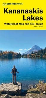
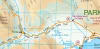
Journey through what many consider the most spectacular and visually arresting alpine terrain in Western Canada with the authoritative Kananaskis Lakes Trail Map & Guide by Gem Trek. This premium, double-sided topographic map is the definitive, all-season navigation asset for day hikers, overnight backpackers, mountain bikers, and winter sports enthusiasts. Providing seamless cross-boundary coverage, the map charts the dramatic mountain corridors of Peter Lougheed Provincial Park, the northern tier of Elk Lakes Provincial Park, and the upper Smith-Dorrien-Spray Trail corridor stretching south of Mount Shark.
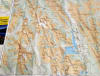
The primary map face features Gem Trek's trademark detailed cartography, pairing high-accuracy contour lines at precise 25-metre intervals (80 feet) with advanced relief shading. This high-contrast terrain rendering brings soaring limestone peaks, hanging glaciers, and deep lake basins to life, providing outdoor enthusiasts with an indispensable, signal-free safety guide for navigating the remote backcountry.
Whether you are exploring under the summer sun or navigating deep winter snowpacks, this comprehensive guide features exact route tracking for the region's most iconic trails:
Premier Summer Day Hikes: Plan your perfect route along the Upper Kananaskis Lake Circuit, Rawson Lake, Elbow Lake, Chester Lake, Burstall Pass, Headwall Lakes, Kananaskis Lookout, and Elk Lakes.
Wildflower Hotspots: Features detailed tracking for the spectacular alpine bowl of Ptarmigan Cirque, a paradise where budding botanists have identified more than 80 unique species of subalpine wildflowers.
Dedicated Winter Snowshoe Networks: This updated edition explicitly maps out seven dedicated snowshoe trails, including winter routes at Chester Lake, Hogarth Lakes, Lower Lake, Penstock, Elkwood, Sawmill, and the 5-km Mount Wintour stretch commencing directly at the Highway 40 winter gate.
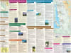
Turn the map over to unlock a comprehensive, full-color field guide and strategic planning matrix. The reverse side functions as an interactive wilderness directory, featuring:
Micro-Scale Topo Inset: Includes a specialized, high-resolution 1:25,000-scale inset map focusing explicitly on the immediate Kananaskis Lakes core area to simplify navigation at busy day-use trail junctions.
The Multi-Sport Directory: Delivers vibrant photographs and detailed route descriptions for 16 recommended day hikes, 3 classic overnight backpacking trips, and 9 classic mountain bike rides.
Winter Sports Matrix: Spotlights six recommended routes tailored specifically for novice and intermediate snowshoers, alongside two prime areas highly recommended for cross-country skiing.
Vital Resource Logistics: Provides essential contact information for regional Alberta Parks visitor centers, backcountry campgrounds, front-country hotels, and alpine lodges to ensure proactive trip preparation.
100% Waterproof & Tear-Resistant Synthetic Material: Purpose-built to survive the highly volatile elements of the Canadian Rockies. This heavy-duty map will not bleed, fray at the corners, or disintegrate when exposed to sudden alpine blizzards, driving backcountry rain, or heavy handling at the trailhead.