QUESTIONS? CALL OR TEXT! 1 (877) 921-6277 or (403) 266-2241
WE SHIP EVERYWHERE!


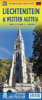
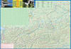
Explore the heart of the Alps with the definitive Liechtenstein & Western Austria Regional Map. This dual-purpose travel guide is expertly designed for motorists, hikers, and winter sports enthusiasts seeking to discover the Principality and the surrounding Austrian Vorarlberg region. Featuring vivid elevation color-coding, this map provides a clear topographical understanding of the rugged Alpine terrain, from the Rhine Valley floor to the soaring peaks of the Rätikon range.
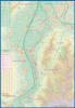
This map goes far beyond basic navigation. It serves as a comprehensive lifestyle guide, marking essential infrastructure such as schools, shopping centers, and churches, alongside tourist-centric points of interest. For those heading to the mountains, the map features a specialized high-scale inset of the premier ski resort, Malbun, showing every major street and facility in detail. Outdoor explorers will benefit from the clearly marked walking and hiking trails that crisscross the border, while the GPS-compatible grid ensures precision for modern navigators. Whether you are touring the capital of Vaduz, skiing the Malbun slopes, or driving through the scenic Vorarlberg passes, this map is your ultimate Alpine companion.
Coverage: The entire Principality of Liechtenstein (including Vaduz, Schaan, and Triesenberg) and the Western Austria/Vorarlberg region.
Topography: High-contrast color-coded elevation shading to illustrate mountain ranges and valley depths.
Urban & Rural Detail: Includes essential community landmarks like schools, churches, hospitals, and major shopping districts.
Outdoor Exploration: * Dedicated walking and hiking trail networks.
Specialized Malbun Inset: A detailed scale map of the ski haven, identifying every major street.
Navigation Ready: Major highways, secondary roads, and scenic alpine passes are clearly distinguished for drivers and cyclists.
This map is particularly valuable for those navigating the unique geography of the region. Because Liechtenstein is one of the world's smallest countries, a map that seamlessly integrates the surrounding Austrian infrastructure is essential for practical travel, grocery runs, and accessing regional rail links.