QUESTIONS? CALL OR TEXT! 1 (877) 921-6277 or (403) 266-2241
WE SHIP EVERYWHERE!


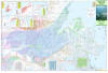
Navigate one of the world's most spectacular and remote northern aquatic corridors with the authoritative MacKenzie Delta (MacKenzie River 6) Map. Purpose-built for wilderness canoeists, intrepid overland drivers, researchers, and Arctic explorers, this comprehensive map charts the final dramatic stretch of Canada's longest river system. Covering the vast expanse from Tsiigehtchic north to Tuktoyaktuk on the shores of the Arctic Ocean, this map delivers vital geographic context and logistical security for traveling through the heart of the Northwest Territories' Inuvialuit Settlement Region and Gwich'in Settlement Area.
Printed on high-contrast paper and measuring a generous 41.5" x 27", this map balances a broad 1:250,000 regional scale with advanced shaded relief. This allows paddlers and overland travelers to easily read the complex topography, labyrinthine delta channels, shifting pingo ice mounds, and sprawling tundra flats that define the lower Mackenzie basin.
Because traveling in the sub-Arctic requires absolute self-reliance, this map features high-density, large-scale town insets for the key frontier settlements along the route. These detailed community blueprints function as an all-in-one survival and navigation index, featuring:
Emergency Infrastructure: Directly lists local emergency phone numbers, RCMP contact info, and local Health Centre locations.
Essential Supply & Service Coordinates: Quickly find local grocery stores, fuel stations, marine docks, and community visitor centers.
Frontier Outposts Detailed: Comprehensive layouts for Tsiigehtchic (formerly Arctic Red River), Inuvik (the regional hub), Aklavik (in the heart of the west delta), and Tuktoyaktuk (the historic coastal hamlet).
Far more than a simple river chart, this map is an indispensable asset for both water and land travel. It provides precise tracking for paddlers tracing the East, Middle, and West channels of the massive delta, while seamlessly mapping the path of the iconic Inuvik-Tuktoyaktuk Highway (ITH). This ensures that whether you are navigating complex river sandbars by canoe, tracing shipping lanes by boat, or driving a 4x4 overland to touch the Arctic Ocean, you have a definitive, signal-free reference guide.
Equipped with an intuitive place-name index, historical notes, and an easy-to-read legend, this large-format map stands as your ultimate safety companion for exploring the wilderness of Canada’s Far North.
NOTE - The paper version is sent folded, and the laminated version is shipped rolled in a tube.