QUESTIONS? CALL OR TEXT! 1 (877) 921-6277 or (403) 266-2241
WE SHIP EVERYWHERE!

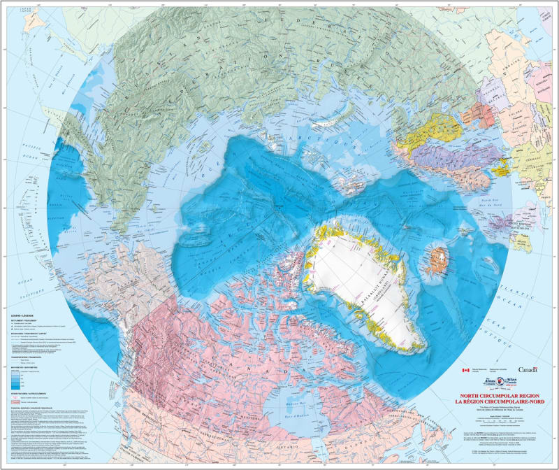


Explore the top of the world with the North Circumpolar Region Wall Map, an authoritative, bilingual reference from the prestigious Atlas of Canada series. This detailed map provides a comprehensive look at the geography, maritime boundaries, and environmental features of the high latitudes.
Whether you are a researcher, educator, or cartography enthusiast, this map offers a unique perspective on the Arctic using the Azimuthal Equidistant projection.
This isn't just a map; it’s a data-rich snapshot of the northern hemisphere's evolving landscape.
Extensive Coverage: Detailed mapping of all regions north of 50° latitude, with the Russian Federation shown north of 60° latitude.
Official Boundaries: Clearly demarcated national, provincial, and territorial borders, including Canada’s 200 nautical mile Exclusive Economic Zone (EEZ).
Arctic Chronology: Tracks the Magnetic North Pole's movement from 1831 to 2007 and displays the minimum permanent polar sea ice extent (1972–2007).
Terrain & Bathymetry: High-resolution land relief and updated undersea relief based on the International Bathymetric Chart of the Arctic Ocean.
Populated Places: Accurate locations for cities, towns, villages, and even seasonally populated hamlets
| Feature | Details |
| Series | Atlas of Canada Reference Map Series |
| Projection | Azimuthal Equidistant |
| Language | Bilingual (English & French) |
| Data Currency | Cultural features updated to 2008; Sea ice/Magnetic Pole to 2007 |
| Environmental Markers | Tree line, glaciers, ice fields, and coastal ice shelves |
The Natural Resources Canada wall map is renowned for its scientific accuracy. It serves as a vital tool for understanding undersea feature names, bathymetric tints, and the historical retreat of Arctic ice shelves. It’s a must-have for anyone studying circumpolar geopolitics or northern environmental shifts.