QUESTIONS? CALL OR TEXT! 1 (877) 921-6277 or (403) 266-2241
WE SHIP EVERYWHERE!

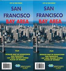


Explore the City by the Bay and its sprawling surrounding region with the ultimate San Francisco Bay Area Travel Map. This comprehensive, highly detailed folding map is an indispensable tactical resource for tourists, road-trippers, and locals looking to seamlessly navigate the unique geography of Northern California. Combining wide-area highway routing with hyper-detailed urban close-ups, this multi-functional map ensures you will never get lost between the Pacific coast and the East Bay.
This premium travel map features dual-sided, high-clarity mapping tailored for effortless exploration. One side provides a massive, regional overview of the entire Bay Area highway network, seamlessly connecting San Francisco, San Jose, Oakland, and the wine country of Napa and Sonoma. The reverse side features an ultra-detailed street map of Downtown San Francisco, explicitly calling out major thoroughfares, neighborhood boundaries, and iconic topography. To take the stress out of urban commuting, the map includes a dedicated, easy-to-read schematic of the Bay Area Transit System (BART, Caltrain, and Muni), making public transportation a breeze. Thousands of places of interest—including the Golden Gate Bridge, Fisherman’s Wharf, Alcatraz ferries, golden state parks, and hidden scenic lookouts—are clearly marked alongside a comprehensive street index for rapid destination plotting.