QUESTIONS? CALL OR TEXT! 1 (877) 921-6277 or (403) 266-2241
WE SHIP EVERYWHERE!


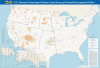
Examine tribal sovereignty, land tenure, and administrative structures across the United States with the official USA Federally Recognized Tribes Wall Map, produced by the Bureau of Indian Affairs (BIA). Rendered at a scale of 1:4,250,000 and measuring a large 47x32 inches, this authoritative cartographic reference delivers a comprehensive geographic overview of sovereign Indigenous nations, tribal lands, and federal administrative jurisdictions across the country.
Designed for legal professionals, researchers, educators, government agencies, and policy analysts, this specialized thematic map illustrates the spatial distribution and organizational framework of federally recognized American Indian and Alaska Native entities. It clearly delineates reservation boundaries, trust lands, Tribal Statistical Areas (TSAs), and Alaska Native Regional Corporations alongside BIA regional office divisions.
Authoritative BIA Cartography: Official Bureau of Indian Affairs spatial data depicting land areas of all federally recognized tribes across the lower 48 states and Alaska.
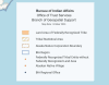
Complete Land & Statistical Area Coverage: Clearly identifies federally recognized tribal reservations, off-reservation trust lands, Joint Use Areas, and Oklahoma Tribal Statistical Areas (OTSAs).
Alaska Native Governance & Boundaries: Features dedicated mapping of Alaska Native Regional Corporation boundaries, Village Statistical Areas (ANVSAs), and native village entities.
BIA Administrative Infrastructure: Pinpoints BIA Regional Offices and agency locations that oversee trust resources, social services, and intergovernmental relations.
Non-Reservation Tribal Entity Locations: Displays geographic points for federally recognized tribal entities that do not currently possess federally recognized land bases.
Large-Format Spatial Planning Reference: Dimensions of 47x32 inches at 1:4,250,000 scale make this wall chart an ideal, highly legible centerpiece for boardrooms, classrooms, legal offices, and government agency walls.
Whether conducting legal research, developing intergovernmental policy, or teaching American Indian history and governance, the USA Federally Recognized Tribes Wall Map provides essential spatial accuracy and administrative clarity.