QUESTIONS? CALL OR TEXT! 1 (877) 921-6277 or (403) 266-2241
WE SHIP EVERYWHERE!


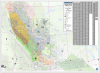


Visualize the energy landscape of the WCSB with the Western Canada Strikes and Play Locations Map. This professional-grade, large-format map is the definitive spatial reference for the energy sector, offering an "at-a-glance" overview of the most significant oil and gas activity in North America. Specifically designed as a high-level strategic tool, it identifies Oil and Gas Strike Areas for British Columbia and Alberta, alongside established Oil and Gas Fields for Saskatchewan and Manitoba.
This map goes beyond mere surface data by depicting the geological extent of the region’s major sedimentary basins and formations. It features detailed overlays for critical plays, including the Montney, Duvernay, Bakken (Williston Basin), and Cardium, as well as the massive Athabasca, Cold Lake, and Peace River Oil Sands. Whether you are analyzing the Horn River Basin, the Leduc Reefs, or the Peace River Arch, this map serves as a vital pre-planning resource for infrastructure development, investment analysis, and business decision-making. Professionally laminated for long-term durability, it is perfect for boardroom discussions or site office use, allowing for the use of dry-erase markers to track emerging trends across the Western Canadian Sedimentary Basin.
Unconventional Shales & Siltstones: Montney, Duvernay, Horn River, Muskwa, and Cordova Embayment.
Oil Sands Deposits: Athabasca, Cold Lake, Peace River, and Surface Mineable Oil Sands areas.
Classic & Deep Basin Plays: Leduc Reefs, Cardium, Viking, Pembina, and Peace River Arch.
Williston Basin & Eastern Plays: Bakken, Shaunavon, Birdbear, and the Eastern Shelf.
Regional Bounds: Clearly defined edge of the Western Canadian Sedimentary Basin (WCSB).
Format: Large Wall Map (approx. 55"x40")
Finish: Heavy-duty 1.7mil lamination (dry-erase compatible)
Coverage: British Columbia, Alberta, Saskatchewan, and Manitoba.
Use Case: Executive briefings, land department planning, and educational energy displays.