QUESTIONS? CALL OR TEXT! 1 (877) 921-6277 or (403) 266-2241
WE SHIP EVERYWHERE!


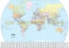
Explore the globe with the ultimate all-in-one World Reference Folded Map. This comprehensive political world map is meticulously designed for students, global business professionals, and curious travelers. Beyond standard continental borders, this map serves as a high-density data hub, featuring an enlarged version of Europe to ensure clarity in one of the world's most complex regional layouts.
Comprehensive Global Intelligence:
Visual Flag Reference: Includes a dedicated section featuring the flags for the countries of the world, making it a perfect educational resource for flag identification and vexillology.
Global Logistics & Time: Stay synchronized with a built-in World Time Zone map, essential for coordinating international calls, travel, or shipping across 24 time zones.
Polar Exploration: Features specialized inset maps for the Arctic Ocean and Antarctic regions, providing a complete view of the Earth from pole to pole.
Europe in Detail: A unique "Europe Enlargement" inset allows for easy reference of smaller sovereign nations and borders that are often lost on standard global scales.
Master Indexing: Navigate the world with confidence using the comprehensive country and place name index, designed for rapid location finding.
Compact enough to fit in a briefcase yet detailed enough for classroom study, this folded world map is your essential guide to our ever-changing planet.