QUESTIONS? CALL OR TEXT! 1 (877) 921-6277 or (403) 266-2241
WE SHIP EVERYWHERE!

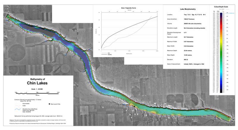
Target key underwater structure and navigate southern Alberta’s expansive irrigation reservoir with the official Chin Lakes Bathymetric Chart. Situated east of Lethbridge across Townships 7 and 8, Ranges 16, 17, and 18 W4, Chin Coulee / Chin Lakes is a renowned destination for walleye, northern pike, and yellow perch angling. This high-precision color depth map converts complex underwater surveys into clear visual data, giving boaters and anglers a definitive tactical advantage on the water.
Much like a terrestrial topographic map reveals land contours, this bathymetric chart details sub-surface depth gradients, steep coulee drop-offs, underwater points, and deep basin trenches. Rendered at a 1:20,000 scale with 1.0-meter contour intervals, it maps out the reservoir's impressive 24.7-kilometer length and maximum depth of 22.64 meters, eliminating the guesswork when locating productive holding zones across the system.
Detailed 1.0m Depth Contours: High-contrast color gradient shading paired with 1.0-meter contour lines highlights steep drop-offs, shallow flats, and deep channel trenches down to 22.64 meters.
Comprehensive Lake Morphometry Data: Includes precise technical statistics detailing surface area (1,568.97 hectares), volume (200,851.98 cubic decametres), shoreline length (66.2 km), mean depth (12.80 m), and elevation.
Access & Boat Launch Facilities: Clearly identifies public boat launch access points, shoreline boundaries derived from orthophoto imagery, and surrounding coulee geography.
Fisheries & Angling Optimization: Essential physical tool for trolling long drop-offs, vertical jigging submerged points, or targeting ice-fishing structure.
Geospatial Precision & Hydrological Curves: Features complete DLS grid references (Twp 7 & 8, Rge 16, 17 & 18 W4), a full Colour/Depth Scale, a 1.5 km scale bar, and an Area/Capacity Curve graph.
Whether launching a boat for summer walleye trolling or drilling holes along deep coulee drop-offs in winter, this bathymetric depth chart is an essential physical guide for exploring Chin Lakes.