QUESTIONS? CALL OR TEXT! 1 (877) 921-6277 or (403) 266-2241
WE SHIP EVERYWHERE!

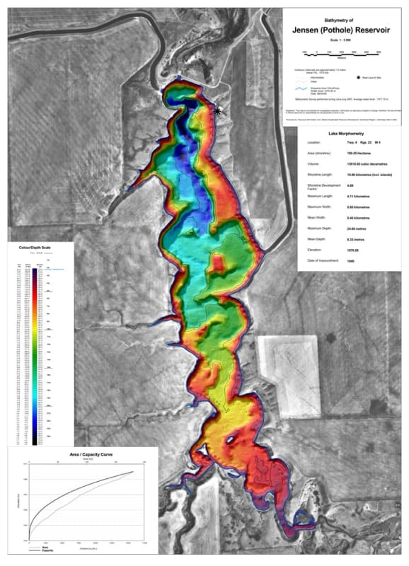
Target trout and sportfish structure on one of southern Alberta’s most scenic coulee reservoirs with the official Jensen (Pothole) Reservoir Bathymetric Chart. Located south of Magrath in Township 4, Range 22, W4 (Warner County / Cardston County area), Jensen Reservoir—locally known as Pothole Reservoir—is a favored destination for rainbow trout angling, kayaking, and quiet water recreation. This high-precision color depth map translates complex underwater bathymetry into clear spatial data, giving boaters and anglers a distinct advantage on the water.
Much like a terrestrial topographic map reveals land contours, this bathymetric chart illustrates underwater depth gradients, steep coulee wall drop-offs, submerged points, shelf transitions, and deep basin depressions. Rendered at a highly detailed 1:5,000 scale with 1.0-meter contour intervals, it maps out the reservoir's 19.96-kilometer shoreline and maximum depth of 24.66 meters, taking the guesswork out of locating productive holding structure.
Detailed 1.0m Depth Contours: Features vivid color gradient rendering paired with 1.0-meter contour lines, clearly highlighting shallow coulee margins (red/orange) down to deep channel trenches (dark blue/purple) reaching 24.66 meters.
Complete Lake Morphometry Data: Includes technical metrics detailing surface area (189.45 hectares), volume (15,810.80 cubic decametres), shoreline length (19.96 km), maximum length (4.11 km), maximum width (0.80 km), mean depth (8.35 m), elevation (1,070.55 m), and 1948 impoundment history.
High-Resolution 1:5,000 Scale Cartography: Exceptional spatial detail paired with a 500-meter scale bar and high-contrast orthophoto background for precise shoreline reference.
Access & Boat Launch Facilities: Prominently marks public boat launch access points along the northeastern shoreline and details surrounding coulee features.
Fisheries & Angling Optimization: Essential physical reference for trolling deep coulee drop-offs, casting shoreline structure, vertical jigging, and locating winter ice-fishing spots.
Geospatial & Hydrological Precision: Features complete DLS grid location details (Twp 4, Rge 22, W4), a full Colour/Depth Scale table, and an Area/Capacity Curve graph.
Whether trolling deep coulee channels during summer or drilling holes across basin drop-offs during ice season, this bathymetric depth map is an indispensable physical reference for exploring Jensen Reservoir.