QUESTIONS? CALL OR TEXT! 1 (877) 921-6277 or (403) 266-2241
WE SHIP EVERYWHERE!


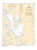
Navigate the heart of Ontario’s premier cottage country with Nautical Chart 6021. This essential hydrographic map provides comprehensive, large-scale coverage of Lake Muskoka, offering the detailed data required to safely traverse its island-dotted waters, hidden shoals, and busy channels.
Chart 6021 is the definitive guide for boaters moving between Gravenhurst, Bracebridge, and Port Carling. It features precise bathymetric soundings, identifies hazardous rocky outcroppings, and marks all official navigational aids, including buoy channels and lights. Whether you are captaining a historic wooden launch or a modern cruiser, this chart provides the professional accuracy needed to navigate the "Big Three" lakes' intricate shoreline and various small island groups.
Key Features:
Complete Lake Coverage: Detailed mapping of the entirety of Lake Muskoka, including the main basin and narrowed arms.
Hydrographic Precision: Features updated depth contours and bottom characteristics essential for safe anchoring and dock approaches.
Navigation & Safety: Clear identification of speed zones, submerged hazards, and the Small Craft Route markers.
Cottage Country Essential: A must-have for residents and visitors exploring the scenic routes toward the Indian River and the Port Carling locks.