QUESTIONS? CALL OR TEXT! 1 (877) 921-6277 or (403) 266-2241
WE SHIP EVERYWHERE!

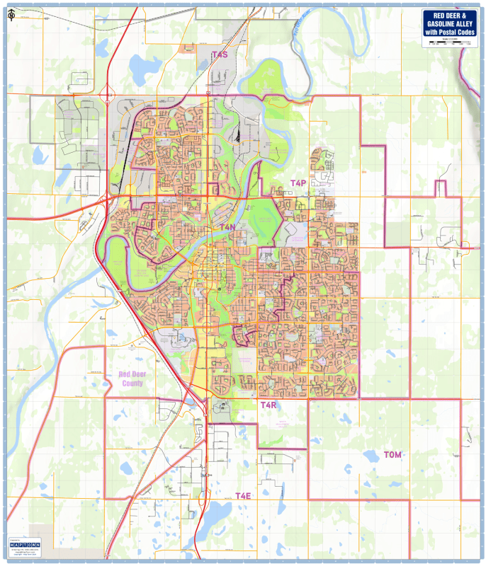
Navigate the commercial and residential hub of Central Alberta with the Red Deer & Gasoline Alley Postal Codes Wall Map (Large 36x42 Edition). Purpose-built for courier dispatch centers, sales territory planning, municipal logistics, real estate offices, and corporate operations, this expansive 36 x 42 inch wall map offers the most detailed physical cartography available for the City of Red Deer and surrounding Red Deer County corridors.
Engineered by MapTown for maximum legibility and spatial accuracy, this large-format reference guide clearly delineates Forward Sortation Area (FSA) postal code boundaries—showing the first three characters (e.g., T4N, T4P, T4R, T4E, T4S, T0M) overlaid directly onto a high-contrast street grid. From the retail hubs of Gasoline Alley to suburban neighborhoods and industrial parks, this map provides immediate clarity for logistical planning and service routing.
FSA Postal Code Boundaries: Prominently outlines Forward Sortation Areas (3-digit postal code zones) across Red Deer, Gasoline Alley, and adjacent rural county districts.
Complete Road & Rail Infrastructure: High-contrast rendering highlights major highways (including Highway 2 / Queen Elizabeth II Highway), primary arteries, secondary roads, local residential streets, and main rail networks.
Essential Community Services Iconography: Features intuitive symbols for vital public safety and emergency infrastructure, including police stations, fire halls, EMS stations, hospitals, and public/catalyst schools.
Civic & Commercial Points of Interest: Identifies primary shopping centers, industrial districts, community centers, public libraries, major sports arenas, and civic landmarks.
Parks, Recreation & Topography: Clearly displays the Red Deer River corridor, tributary creeks, urban green spaces, municipal parks, golf courses, and neighborhood boundaries.
Expansive 36" x 42" Large Format: High-resolution presentation makes it an ideal wall-mounted focal point for fleet dispatching, territory mapping, boardroom planning, or regional analysis.
Whether managing courier routes, structuring corporate sales territories, or planning local emergency response zones, this large-format Red Deer postal code map provides the granular clarity required for everyday operational efficiency.