QUESTIONS? CALL OR TEXT! 1 (877) 921-6277 or (403) 266-2241
WE SHIP EVERYWHERE!

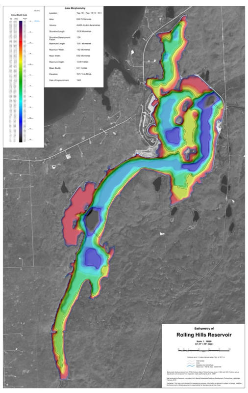
Maximize your fishing success and safely navigate southern Alberta's premier warm-water fishery with the Rolling Hills Reservoir Bathymetric Chart. Located south of Brooks in the County of Newell, Rolling Hills Reservoir is renowned among anglers for producing giant northern pike, walleye, and lake whitefish. This high-precision underwater depth map converts complex hydrological data into an easy-to-read visual guide to the reservoir's bottom structure.
Designed similarly to a land topographic map, this bathymetric chart uses precise depth contours to expose underwater drop-offs, submerged river channels, shallow weedlines, island humps, and deep basin holes. Whether you are trolling deep channels in summer or setting up ice shelters over subtle transitions in winter, this map provides the spatial insight needed to locate holding fish efficiently.
High-Definition Depth Contours: Features precise underwater contour intervals revealing steep drop-offs, submerged weedbeds, shoals, mid-lake humps, and old river channel structures.
Targeted Tactical Advantage: Ideal for walleye and northern pike anglers looking to identify high-probability structure for trolling, casting, vertical jigging, and ice fishing.
Navigational Hazards & Facilities: Highlights public boat launches, campground access points, day-use areas, shallow shoals, and hazards to protect boat hulls and propellers.
Geospatial Compatibility: Designed with accurate scale and orientation to simplify cross-referencing with marine chartplotters, handheld GPS units, and fishfinders.
Water-Resistant Field Durability: Printed on heavy-duty stock designed to withstand spray, wet hands, and outdoor use on boats or ice.
Whether launching for a summer walleye derby or drilling holes across mid-lake structure during ice season, this bathymetric depth chart is an essential physical reference for Rolling Hills Reservoir.