• QUESTIONS? CALL OR TEXT! 1 (877) 921-6277 or (403) 266-2241

  • WE SHIP EVERYWHERE!

  • QUESTIONS? CALL OR TEXT! 1 (877) 921-6277 or (403) 266-2241

  • WE SHIP EVERYWHERE!

Prices are in Canadian funds

Home >
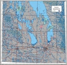
Detailed Southern Manitoba provincial base map showing roads, waterways, and cities at a 1:500,000 scale.

Southern Manitoba Provincial Base Map | 1:500,000 Detailed Topo Guide

Manitoba Conservation
$
Choose your options:
Style(optional):
Product Code: 30903

Navigate the heart of the prairies with the Manitoba Provincial Base Map South, a high-precision cartographic resource designed for regional planning and deep-territory exploration. Expertly rendered at a detailed 1:500,000 scale, this map offers double the resolution of standard provincial overviews, providing critical clarity for the most populated and agriculturally significant region of the province.

This map serves as a definitive reference for Southern Manitoba’s intricate infrastructure and natural geography. It features an exhaustive transportation network, from major Provincial Trunk Highways to local rural roads, alongside precise mapping of the region’s extensive waterways, including the Red, Assiniboine, and Souris river systems. Every city, town, and village is clearly identified, making it an indispensable tool for logistics professionals, government administrators, and outdoor enthusiasts who require more than just a basic highway guide. The high-contrast design ensures that even the most dense rural grids remain legible for field or office use.

Key Features:

  • Enhanced Scale Resolution: 1:500,000 scale provides superior detail of the Southern Manitoba region.

  • Integrated Infrastructure: Comprehensive mapping of the full road network and provincial highways.

  • Detailed Hydrology: Precisely delineates southern waterways, lakes, and river systems.

  • Settlement Index: Includes all urban centers, rural towns, and small villages with clear population markers.

  • Professional Cartography: Features a clean, professional layout suitable for wall mounting or desktop reference.

  • High-Contrast Design: Optimized for easy reading of local road designations and geographic boundaries.

Empty Cart